Category:Phare de la Hève
Jump to navigation
Jump to search
| Object location | | View all coordinates using: OpenStreetMap |
|---|
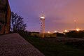
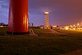
This station was established in 1775 with twin towers, which were destroyed in the Second World War.
|
This building is inscrit au titre des monuments historiques de la France. It is indexed in the base Mérimée, a database of architectural heritage maintained by the French Ministry of Culture, under the reference PA76000090
|
lighthouse in Seine-Maritime, France   | |||||
| Upload media | |||||
| Instance of | |||||
|---|---|---|---|---|---|
| Made from material | |||||
| Location | Sainte-Adresse, Seine-Maritime, Normandy, Metropolitan France, France | ||||
| Heritage designation |
| ||||
 | |||||
Media in category "Phare de la Hève"
The following 7 files are in this category, out of 7 total.
-

-
 Le Havre 2008 PD 03.JPG 1,704 × 2,272; 257 KB
-
 LeHavre Phare de La Hève.jpg 1,600 × 1,200; 649 KB
-
 Phare du Cap de la Hève.jpg 3,648 × 2,736; 3.08 MB
-
 Sainte Adresse - Phare de la Hève au crépuscule.jpg 2,800 × 4,976; 4.34 MB
-
 Sainte-Adresse - Phare de la Hève by night 01.jpg 3,008 × 2,000; 2 MB
-
 Sainte-Adresse - Phare de la Hève by night 02.jpg 3,008 × 2,000; 2.1 MB
.jpg)


Categories:
- Lighthouses built in 1950
- Lighthouses in France by name
- Lighthouses by height, 21 to 30 meters
- Concrete lighthouses
- Monuments historiques in Seine-Maritime (lighthouses)
- Cap de la Hève
- Landfall lights
- Lighthouses by range, 20 to 24 nm
- Lighthouses with focal heights above 100 metres
- Lighthouse equipment by Sautter
- Red and white lighthouses in France