Category:Phare de Pointe-Plate
Jump to navigation
Jump to search
Français : Le phare de Pointe-Plate est un phare situé au sud-ouest de l'île de Langlade, dans l'archipel français de Saint-Pierre-et-Miquelon.
English: The Pointe-Plate (flat point) lighthouse is a located north-west of Langlade Island, in the French archipelago of Saint-Pierre et Miquelon, in North-West Atlantic in the south of New Foundland.
| Object location | | View all coordinates using: OpenStreetMap |
|---|
|
This building is classé au titre des monuments historiques de la France. It is indexed in the base Mérimée, a database of architectural heritage maintained by the French Ministry of Culture, under the reference PA97500012
|
lighthouse in Saint Pierre and Miquelon, France    | |||||
| Upload media | |||||
| Instance of | |||||
|---|---|---|---|---|---|
| Location | Miquelon-Langlade, Saint Pierre and Miquelon, France | ||||
| Owned by | |||||
| Heritage designation |
| ||||
| Inception |
| ||||
| Significant event |
| ||||
 | |||||
Media in category "Phare de Pointe-Plate"
The following 6 files are in this category, out of 6 total.
-
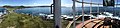 Depuis le phare de Pointe Plate.jpg 8,252 × 1,892; 5.22 MB
-
 Le phare de Pointe Plate, monument classé.jpg 4,928 × 3,094; 10.41 MB
-
 Le phare de Pointe Plate, photo2 monument classé.jpg 4,928 × 3,095; 14.46 MB
-
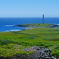 Phare de Pointe Plate.jpg 2,999 × 2,999; 2.4 MB
-
 Phare de Pointe-Plate.jpg 3,577 × 5,366; 17.83 MB
-
 Phare à la pointe de Langlade - plans 1876.jpg 10,848 × 7,373; 19.31 MB


Categories:
- Lighthouses in Saint-Pierre and Miquelon
- Lighthouses in Saint-Pierre and Miquelon by name
- Lighthouses built in 1899
- Lighthouses by height, 41 to 50 meters
- Monuments historiques in Saint-Pierre and Miquelon
- Langlade (Saint-Pierre-et-Miquelon)
- Red and white lighthouses in France
- Lighthouses in France by name