Category:Phantom Canyon
Jump to navigation
Jump to search

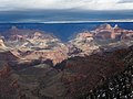
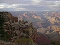
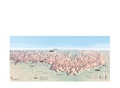
(Note that Tiyo Point-(west), Widforss Point-(east) are also pictured.)
Note massive flat-topped Shiva Temple-(left), and Cheops Pyramid next to Isis Temple.

English: Phantom Canyon, containing Haunted Canyon-(below Widforss Point) & the Phantom Creek watershed. Two minor tributary canyons drain the west & east sides of Sturdevant Point.
- Phantom Ranch is located near the canyon’s terminus, but is located on Bright Angel Creek, in Bright Angel Canyon.
Subcategories
This category has the following 18 subcategories, out of 18 total.
*
B
C
H
I
- Isis Temple, Arizona closeup (14 F)
J
P
- Phantom Canyon closeup (5 F)
S
T
- The Colonnade terminus closeup (13 F)
Media in category "Phantom Canyon"
The following 46 files are in this category, out of 46 total.
-
 0059 Grand Canyon Mather Point Improvements (5373762649).jpg 4,293 × 2,976; 2.24 MB
-
 1 Grandcanyon2 panoram 2010.jpg 6,285 × 2,336; 9.7 MB
-
 12586 Grand Canyon Yavapai Point (7945719124).jpg 1,024 × 720; 292 KB
-
 2012.09.14.084856 View Mather Point Grand Canyon Arizona.jpg 1,920 × 1,280; 1.09 MB
-
 2012.09.14.155238 View South Rim Trail Grand Canyon Arizona.jpg 1,920 × 1,280; 1 MB
-
 ARIZONA (4547398222).jpg 3,648 × 2,736; 3.89 MB
-
 Arizona. LOC 99446124-2.jpg 6,471 × 8,018; 12.08 MB
-
 Arizona. LOC 99446124-4.jpg 6,422 × 8,046; 13.59 MB
-
 Arizona. LOC 99446126-2.jpg 5,014 × 6,252; 6.24 MB
-
 Bright Angel Creek canyon from Rim Trail in Grand Canyon NP.jpeg 1,000 × 663; 100 KB
-
 Bright Angel Trailhead03.jpg 2,520 × 1,680; 2.8 MB
-
 Coconino County, AZ, USA - panoramio (82).jpg 2,048 × 1,153; 1.06 MB
-
 FDuffieldGrandCanyon101.jpg 6,000 × 3,376; 17.7 MB
-

-
 Grand Canyon (1).jpg 3,000 × 2,000; 2.64 MB
-
 Grand Canyon (26554597262).jpg 4,608 × 3,456; 3.04 MB
-
 Grand Canyon - Hopi Point.JPG 6,557 × 2,307; 7.39 MB
-
 Grand Canyon 3-800.jpg 4,608 × 3,456; 5.89 MB
-
 Grand Canyon 3.jpg 4,834 × 3,202; 4.51 MB
-
 Grand Canyon 7.jpg 4,781 × 3,167; 5.08 MB
-
 Grand Canyon Août 2006.jpg 5,319 × 1,061; 2.26 MB
-
 Grand Canyon DEIS Aerial Tiyo Point, Shiva Temple (5477216278).jpg 3,200 × 2,125; 1.29 MB
-
 Grand Canyon du Colorado Arizona (USA).jpg 4,895 × 2,151; 2.06 MB
-
 Grand Canyon February 2012 33.JPG 4,000 × 3,000; 2.28 MB
-
 Grand Canyon Mather Point01.jpg 1,680 × 2,520; 2.8 MB
-
 Grand Canyon panorama of rock formations Aaf11.jpg 1,737 × 1,391; 670 KB
-
 Grand Canyon South Rim 3.JPG 1,600 × 1,200; 406 KB
-
 Grand Canyon Vincent Bloch.jpg 2,560 × 1,920; 3.28 MB
-
 Grand canyon yavapal point 2010.JPG 4,209 × 2,744; 4.55 MB
-
 Grand Canyon, South Rim IMG 4521.tif 5,865 × 3,355; 46.56 MB
-
 Grand Canyon2017.jpg 1,509 × 1,885; 685 KB
-
 GrandCanyon2007a.JPG 2,816 × 2,112; 1.27 MB
-
 GrandNP.jpg 2,288 × 1,712; 873 KB
-
 Looking to North Rim - Flickr - brewbooks.jpg 3,264 × 2,448; 3.87 MB
-
 LookingSouthRim.JPG 4,000 × 2,256; 2.51 MB
-
 Monumental Canyon.jpg 2,816 × 2,112; 1.99 MB
-
 My Public Lands Magazine, Summer 2014 (13949831746).jpg 3,264 × 2,448; 3.37 MB
-
 Near bottom of Grand Canyon - panoramio.jpg 10,950 × 2,106; 18.12 MB
-
 NPS grand-canyon-south-rim-map.pdf 3,258 × 1,472; 13.71 MB
-
 Phantom Creek - Flickr - brewbooks.jpg 3,264 × 2,448; 5.39 MB
-
 Phantom Fault - Flickr - brewbooks (2).jpg 3,193 × 634; 792 KB
-
 Phantom Fault - Flickr - brewbooks.jpg 3,264 × 2,448; 2.65 MB
-
 Shiva Temple aerial.jpg 3,931 × 2,601; 2.45 MB
-
 Sumner Butte.jpg 3,000 × 2,000; 4.7 MB
-
 USA 09855 Grand Canyon Luca Galuzzi 2007.jpg 2,000 × 1,333; 2.99 MB
-
 View of Grand Canyon from Kaibab trail.jpg 3,840 × 2,391; 4.21 MB
.jpg)
.jpg)


.jpg)


.jpg)


.jpg)
.jpg)


.jpg)
.jpg)


.jpg)


.jpg)