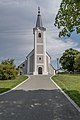
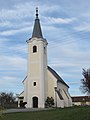
Category:Pfarrkirche hl. Anna, Schandorf
Jump to navigation
Jump to search
| Object location | | View all coordinates using: OpenStreetMap |
|---|
church building in Schandorf, Austria .jpg) | |||||
| Upload media | |||||
| Instance of | |||||
|---|---|---|---|---|---|
| Named after | |||||
| Location | Schandorf, Oberwart District, Burgenland, Austria | ||||
| Heritage designation | |||||
 | |||||
English: Pfarrkirche hl. Anna Schandorf
Deutsch: Pfarrkirche hl. Anna Schandorf
Media in category "Pfarrkirche hl. Anna, Schandorf"
The following 8 files are in this category, out of 8 total.
-
 20210822 WTSB Schandorf 5472.jpg 5,568 × 3,712; 12.3 MB
-
 20210822 WTSB Schandorf 5475.jpg 3,712 × 5,568; 12.78 MB
-
 20210822 WTSB Schandorf 5476.jpg 3,712 × 5,568; 12.49 MB
-
 20210822 WTSB Schandorf 5479.jpg 3,700 × 5,550; 12.58 MB
-
 20210822 WTSB Schandorf 5480.jpg 3,184 × 4,776; 8.3 MB
-
 20210822 WTSB Schandorf 5481.jpg 5,568 × 3,712; 11.6 MB
-
 Pfarrkirche schandorf.JPG 2,736 × 3,648; 1.68 MB
-
 Schandorf - Parish church holy Ann (01).jpg 2,000 × 3,000; 1.07 MB


