Category:Pfarrhaus (Oberlunkhofen)
Jump to navigation
Jump to search
| Object location | | View all coordinates using: OpenStreetMap |
|---|
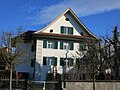
church residential building in Oberlunkhofen in the canton of Aargau, Switzerland  | |||||
| Upload media | |||||
| Instance of | |||||
|---|---|---|---|---|---|
| Part of | |||||
| Location | Oberlunkhofen, Bremgarten District, Aargau, Switzerland | ||||
| Street address |
| ||||
| Architectural style | |||||
| Heritage designation | |||||
| Inception |
| ||||
 | |||||
Media in category "Pfarrhaus (Oberlunkhofen)"
The following 2 files are in this category, out of 2 total.
-
 Oberlunkhofen Pfarrhaus.JPG 2,816 × 2,112; 2.21 MB
-
 Pfarrhaus Oberlunkhofen Frontseite.jpg 3,024 × 2,016; 750 KB
