Category:Pfarrgasse 1 (Bad Camberg)
Jump to navigation
Jump to search
| Object location | | View all coordinates using: OpenStreetMap |
|---|
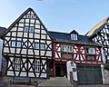
Cultural heritage monument in Bad Camberg, Hesse, Germany  | |||||
| Upload media | |||||
| Instance of | |||||
|---|---|---|---|---|---|
| Location | Bad Camberg, Limburg-Weilburg, Giessen Government Region, Hesse, Germany | ||||
| Street address |
| ||||
| Heritage designation | |||||
 | |||||
This is the category of the Hessian Kulturdenkmal (cultural monument) with the ID 50468 (Wikidata)
|
Media in category "Pfarrgasse 1 (Bad Camberg)"
The following 4 files are in this category, out of 4 total.
-
 Bad Camberg, Pfarrgasse 1, Ecke.JPG 2,470 × 3,377; 2.91 MB
-
 Bad Camberg, Pfarrgasse 1, Front.jpg 5,408 × 4,320; 17.67 MB
-
 Bad Camberg, Pfarrgasse 1, Seite.JPG 2,848 × 4,288; 4.74 MB
-
 Bad-Camberg-Pfarrgasse-1-JR-E-2744-2018-09-02.jpg 3,956 × 3,556; 3.93 MB


