Category:Petroleum region maps
Jump to navigation
Jump to search

Subcategories
This category has the following 3 subcategories, out of 3 total.
Media in category "Petroleum region maps"
The following 112 files are in this category, out of 112 total.
-
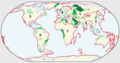 USGS world oil endowment.png 1,047 × 551; 33 KB
-
 Weltkarte konventionelle Öl u. -Gasförderung.png 2,000 × 1,086; 1.12 MB
-
 Weltkarte unkonventionelle Öl- u. Gaslagerstätten.png 2,000 × 1,085; 1.3 MB
-
-

-
 1951 Middle East Oil (30583518490).jpg 1,791 × 982; 1.08 MB
-
 Ambalat Disputed.png 320 × 359; 15 KB
-
 Andamanpook.jpg 415 × 571; 96 KB
-
 Athabasca Oil Sands map.png 1,200 × 1,753; 611 KB
-
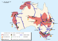 Australian oil and gas facilities map-en.svg 1,146 × 808; 224 KB
-
 Australian oil and gas facilities map-ru.svg 1,146 × 808; 223 KB
-
 Petroleum regions - Australia map-fr.svg 733 × 632; 51 KB
-
 Regiones petroleras - Australia.svg 733 × 632; 52 KB
-
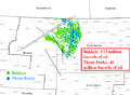
 Bakken map.png 850 × 1,100; 626 KB
-
 Bakken Wells 2008.png 1,095 × 807; 323 KB
-
 Bakken Wells 2013.png 1,095 × 807; 374 KB
-
 Basin Map and Field Location.png 2,113 × 1,306; 839 KB
-
 Beaufort Sea Withdrawal NPR-A Special Areas.jpg 1,224 × 792; 265 KB
-
 Karte Brent-Ölfeld.png 1,405 × 1,209; 203 KB
-
 Brent crude oil map.png 3,300 × 2,550; 243 KB
-
 Brent oilfield.jpg 383 × 393; 99 KB
-
 Caspian region oil and natural gas infrastructure.png 2,700 × 2,550; 265 KB
-
 Caspian sea oil gas-2001.jpg 3,948 × 2,768; 2.45 MB
-
 Petroleum regions - China map-fr.svg 728 × 608; 40 KB
-
 Regiones petroleras - China.svg 728 × 608; 40 KB
-
 Denver Basin Location Map.png 750 × 1,225; 30 KB
-
 EIA Map of Eagle Ford Shale Play.jpg 798 × 613; 102 KB
-
 EIA Shale Gas Europe.png 561 × 581; 493 KB
-
 Erdöl und Erdgas in Europa.svg 1,206 × 1,010; 370 KB
-
 Pétrole et gaz - Europe.svg 1,206 × 1,010; 370 KB
-
 Pétrole et gaz - UE - Europe.svg 2,120 × 1,648; 706 KB
-
 Former USSR Oil and Gas map.svg 1,530 × 990; 1.89 MB
-

-
 Golf Persic - Idrocarburs.png 635 × 711; 125 KB
-
 Gorgon Barrow Island.png 558 × 447; 194 KB
-
 Indonesia Oil & Gas (30249692363).jpg 3,204 × 1,580; 3.26 MB
-
 Iran oil map.png 1,200 × 1,200; 64 KB
-
 Iran oil reserves map.png 1,200 × 1,200; 100 KB
-
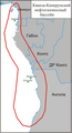
 Key oil and natural gas infrastructure in Azerbaijan.png 900 × 875; 402 KB
-
 LAHydrocarbonPlaysVer001.png 2,203 × 1,842; 1.16 MB
-

-
 Levant Basin-ar.png 846 × 664; 182 KB
-
 Levant Basin.png 846 × 664; 197 KB
-
 Libya location map-oil & gas 2011-en.svg 969 × 929; 842 KB
-
 Libya-Oil.jpg 951 × 712; 157 KB
-
 Long-beach-san-pedro-map.png 1,700 × 2,200; 116 KB
-
 Major Soviet Petroleum Deposits and Pipelines, 1982.png 1,450 × 910; 332 KB
-
 Map Caddo oil field(Louisiana).png 894 × 832; 244 KB
-
 Map of Gallia and Meigs County oil field LOC 2012591125.jpg 8,387 × 11,221; 13.84 MB
-
 Map of Gallia and Meigs County oil field LOC 2012591125.tif 8,387 × 11,221; 269.25 MB
-
 Marcellus Bedrock.svg 540 × 540; 1.21 MB
-
 Marcellus Shale USGS.png 300 × 350; 78 KB
-
 Mid-continent Oil Field map.png 572 × 371; 15 KB
-
 Petroleum regions - Middle East map-es.svg 577 × 592; 145 KB
-
 Petroleum regions - Middle East map-fr.svg 577 × 592; 155 KB
-
 Regiones petroleras - Medio Oriente-ar.svg 616 × 631; 181 KB
-
 Regiones petroleras - Medio Oriente.svg 577 × 592; 150 KB
-
 Mississippi Salt Basin structure map.png 954 × 570; 108 KB
-
 Naval Petroleum and Oil Shale Reserves.gif 905 × 573; 37 KB
-
 Petroleum regions - north Africa map-fr.svg 952 × 583; 78 KB
-
 Regiones petroleras - África del Norte.svg 952 × 583; 78 KB
-
 Petroleum regions - North America map-fr.svg 883 × 914; 137 KB
-
 Regiones petroleras - Norteamérica.svg 883 × 914; 137 KB
-
 North Sea Fields Zoom.jpg 978 × 597; 90 KB
-
 North Sea oil and gas fields.svg 630 × 873; 715 KB
-
 Northeastpook.jpg 732 × 574; 150 KB
-
 Northpook.jpg 547 × 777; 152 KB
-
 NPRA F1lg.gif 2,084 × 822; 99 KB
-
 Ocs status map 8f.jpg 1,750 × 1,500; 853 KB
-
 Oil wells and refineries France map-fr.svg 1,110 × 1,110; 800 KB
-
 Old Harry oil field location map-fr.svg 1,655 × 1,582; 3.04 MB
-
 Orinoco USGS.jpg 719 × 611; 246 KB
-
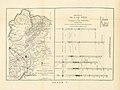
 Petroleum in Rumania (1900).JPG 2,660 × 3,496; 2.11 MB
-

-
 Pre sal (2).jpg 790 × 768; 80 KB
-
 Pre sal medio.jpg 853 × 768; 109 KB
-
 Pétrole et gaz - Péninsule indienne.svg 722 × 635; 42 KB
-
 RUS oilmap.gif 870 × 638; 309 KB
-
 Petroleum regions - Russia map-fr.svg 985 × 746; 246 KB
-
 Regiones petroleras - Rusia.svg 985 × 746; 246 KB
-

-
 Santa-barbara-map.png 2,200 × 1,700; 145 KB
-
 Santa-maria-map.png 2,200 × 1,700; 100 KB
-
 Santos basin map.png 990 × 609; 550 KB
-
 Siberian oil fields.jpg 2,022 × 1,985; 324 KB
-
 Sincor Orinocobeltet.png 1,268 × 881; 495 KB
-
 Smackover Formation areal extent.png 1,180 × 473; 820 KB
-
 Petroleum regions - south america map-es.svg 579 × 762; 243 KB
-
 Petroleum regions - south america map-fr.svg 579 × 762; 296 KB
-
 Petroleum regions - south america map-mk.svg 579 × 762; 299 KB
-
 Regiones petroleras - Sudamérica.svg 579 × 762; 300 KB
-
 Petroleum regions - Southeast asia map-fr.svg 729 × 521; 314 KB
-
 Southpook.jpg 1,143 × 1,692; 668 KB
-
 Special Areas within the NPR-A.jpg 4,437 × 2,749; 1.83 MB
-
 Tupi.jpg 1,836 × 1,836; 239 KB
-
 US-reserves-USGS.png 719 × 501; 654 KB
-
 USEIA Shale Gas Poland.png 561 × 581; 314 KB
-
 USGS - Bazhenov Formation Oil Reservoir.png 1,150 × 1,325; 78 KB
-
 Venezuela petrol 1972.jpg 855 × 753; 131 KB
-
 Petroleum regions - West Africa map-es.svg 1,270 × 1,229; 147 KB
-
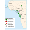 Petroleum regions - West Africa map-fr.svg 1,270 × 1,229; 147 KB
-
 Regiones petroleras - África Occidental.svg 1,270 × 1,229; 148 KB
-
 Willow Development Lease Map.jpg 1,044 × 651; 281 KB
-
 Гавар.png 1,850 × 2,415; 341 KB
-
 Карта нефтегазовых месторождений Казахстана.jpg 1,287 × 1,571; 1.05 MB
-
 Кванза-Камерунский НГБ.png 1,708 × 3,157; 512 KB
-
 Н Оперейтинг Компани.png 1,420 × 1,490; 170 KB
-
 НГБ Гвинейского залива.png 2,254 × 1,507; 471 KB
-
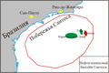 НГП Сантоса.png 2,218 × 1,480; 639 KB
-
 НГП СНГ и Балтики.png 3,540 × 1,453; 528 KB
-
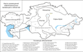 Нефтегазоносные провинции Казахстана.png 2,448 × 1,542; 542 KB
-
 Туркменские НГП.png 2,865 × 1,782; 652 KB


.jpg)
.jpg)
.jpg)


.jpg)


.png)


.JPG)

.jpg)


_and_Ester,_Emmy,_Eva_(state_leases)_(cropped).png)


