Category:Perlacher Forst
Jump to navigation
Jump to search

unincorporated area in Germany   | |||||
| Upload media | |||||
| Instance of |
| ||||
|---|---|---|---|---|---|
| Part of | |||||
| Located in protected area | |||||
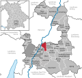
| Location | Munich, Upper Bavaria, Bavaria, Germany | ||||
| Population |
| ||||
| Area |
| ||||
| Elevation above sea level |
| ||||
 | |||||
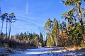
Deutsch: Der Perlacher Forst ist ein 13,36 km² großes gemeindefreies Waldgebiet im Südosten von München.
This is the category of the protected area listed at WDPA under the ID 396067
|
Subcategories
This category has only the following subcategory.
K
- Kiesweiher (Perlacher Forst) (16 F)
Media in category "Perlacher Forst"
The following 90 files are in this category, out of 90 total.
-
 Bahntrasse durch den Perlacher Forst - geo.hlipp.de - 9891.jpg 426 × 640; 208 KB
-
 Benches at Perlacher Forst.jpg 4,000 × 2,248; 1.18 MB
-
 Chopped wood at Perlacher Forst, Munich.jpg 4,000 × 2,248; 1.05 MB
-
 Dillis-Stein-1.jpg 1,908 × 2,172; 1.22 MB
-
 Episyrphus balteatus side.jpg 2,600 × 1,736; 1.62 MB
-
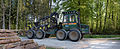 Forestry Forwarder Ösa 250 2.jpg 4,000 × 1,640; 9.44 MB
-
 Forestry Forwarder Ösa 250.jpg 1,667 × 2,500; 4.24 MB
-
 Funkturm im Perlacher Forst - geo.hlipp.de - 9893.jpg 426 × 640; 235 KB
-
 Geiselgasteig-Geräumt.jpg 1,536 × 2,048; 1.12 MB
-

-
 Hirschbrunnen Perlacher Forst 1.jpg 5,472 × 3,648; 14.2 MB
-
 Hirschbrunnen Perlacher Forst 2.jpg 5,472 × 3,648; 13.31 MB
-
 Hirschbrunnen Perlacher Forst 3.jpg 3,648 × 5,472; 11.19 MB
-
 Hochsitz perfekt versteckt im Perlacher Forst.jpg 2,736 × 3,648; 6.32 MB
-
 Krötenteich.jpg 2,592 × 1,456; 1.64 MB
-
 Muggl.JPG 2,016 × 1,512; 632 KB
-
 Munich Oct 2020 12 03 29 796000.jpeg 3,024 × 4,032; 5.76 MB
-
 Munich Oct 2020 12 03 47 952000.jpeg 3,024 × 4,032; 5.48 MB
-
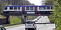
 München, Bahnbrücke Geiselgasteigstraße, 1.jpeg 5,056 × 2,528; 5.46 MB
-
 München, Bahnbrücke Geiselgasteigstraße, 2.jpeg 5,120 × 3,200; 6.24 MB
-
 München, Bahnbrücke Geiselgasteigstraße, 3.jpeg 5,056 × 2,528; 5.51 MB
-
 München, Bahnbrücke Geiselgasteigstraße, 4.jpeg 3,200 × 1,600; 2.79 MB
-
 Outdoor Shooting Range - Perlacher Forst.JPG 2,048 × 1,536; 540 KB
-
 Outdoor Shooting Range Perlacher Forst total view.JPG 2,048 × 1,536; 566 KB
-
 Parkplatz Perlacher Forst Perlach-Geräumt Unterhaching-Nord als Müllabladeplatz.jpg 3,648 × 2,736; 5.54 MB
-
 Perlacher Forst - panoramio.jpg 800 × 600; 187 KB
-
 Perlacher forst 001.jpg 1,000 × 600; 784 KB
-
 Perlacher forst 003 quadrat.jpg 1,000 × 1,000; 1.46 MB
-
 Perlacher forst 006.jpg 1,000 × 1,000; 1.7 MB
-
 Perlacher Forst 1.jpeg 4,742 × 3,158; 3.77 MB
-
 Perlacher Forst 10.jpg 1,777 × 2,669; 800 KB
-
 Perlacher Forst 11.jpeg 4,652 × 3,137; 3.25 MB
-
 Perlacher Forst 12.jpeg 2,168 × 3,253; 1.87 MB
-
 Perlacher Forst 13.jpeg 2,722 × 1,830; 1.07 MB
-
 Perlacher Forst 14.jpg 4,729 × 3,152; 1.5 MB
-
 Perlacher Forst 15.jpg 4,625 × 2,978; 4.78 MB
-
 Perlacher Forst 16.jpeg 4,750 × 3,167; 6.02 MB
-
 Perlacher Forst 17.jpg 4,729 × 3,153; 5.04 MB
-
 Perlacher Forst 18.jpg 4,748 × 3,166; 7.7 MB
-
 Perlacher Forst 19.jpg 2,869 × 1,861; 1.95 MB
-
 Perlacher Forst 2.jpeg 3,999 × 2,666; 4.09 MB
-
 Perlacher Forst 20.jpg 4,210 × 2,807; 3.65 MB
-
 Perlacher Forst 3.jpg 4,307 × 2,872; 2.66 MB
-
 Perlacher Forst 4.jpeg 4,714 × 3,143; 4.9 MB
-
 Perlacher Forst 5.jpg 2,987 × 4,481; 2.12 MB
-
 Perlacher Forst 6.jpeg 2,367 × 3,154; 1.92 MB
-
 Perlacher Forst 7.jpeg 3,823 × 2,531; 1.9 MB
-
 Perlacher Forst 8.jpg 4,749 × 2,692; 2.12 MB
-
 Perlacher Forst 9.jpg 1,910 × 1,265; 755 KB
-
 Perlacher Forst im schönsten Sonnenlicht.jpg 5,032 × 3,494; 4.9 MB
-
 Perlacher Forst in M.svg 630 × 597; 637 KB
-
 Perlacher Forst Müllhalde Abfall Asbest.jpg 2,736 × 3,648; 6.9 MB
-
 Perlacher Forst Salzlecke mit Wildkamera.jpg 3,648 × 2,736; 6.69 MB
-
 Perlacher Forst, Bahnbrücke über Fußweg, 1.jpeg 4,800 × 3,200; 9.91 MB
-
 Perlacher Forst, Kiesgrube.jpg 4,032 × 3,024; 5.49 MB
-
 Perlacher Forst- Allerhand Waldwege - geo.hlipp.de - 10471.jpg 640 × 426; 376 KB
-
 Perlacher Forst- Giesinger Waldhaus - geo.hlipp.de - 10472.jpg 640 × 426; 231 KB
-
 Perlacher Forst-1.jpg 1,944 × 2,592; 1.14 MB
-
 Perlacher Forst-10.jpg 5,472 × 3,648; 4.36 MB
-
 Perlacher Forst-2.jpg 5,225 × 3,640; 3.19 MB
-
 Perlacher Forst-3.jpg 5,472 × 3,648; 3.64 MB
-
 Perlacher Forst-4.jpg 3,640 × 5,144; 3.14 MB
-
 Perlacher Forst-5.jpg 5,472 × 3,648; 3.1 MB
-
 Perlacher Forst-6.jpg 4,775 × 3,645; 4.65 MB
-
 Perlacher Forst-7.jpg 3,647 × 5,166; 4.44 MB
-
 Perlacher Forst-8.jpg 5,154 × 3,642; 4.74 MB
-
 Perlacher Forst-9.jpg 5,325 × 3,635; 3.57 MB
-
 Perlacher Muggl - geo.hlipp.de - 9890.jpg 640 × 426; 404 KB
-
 Perlacher Mugl.jpg 5,616 × 3,744; 6.62 MB
-
 Salzlecke Kirrung Sulze auf einem Pfahl im Perlacher Forst.jpg 2,736 × 3,648; 4.44 MB
-
 Spaetsommer Perlacher Forst-1.jpg 5,000 × 3,235; 4.18 MB
-
 Spaetsommer Perlacher Forst-10.jpg 3,647 × 5,173; 5.71 MB
-
 Spaetsommer Perlacher Forst-11.jpg 3,647 × 5,334; 3.99 MB
-
 Spaetsommer Perlacher Forst-13.jpg 5,472 × 3,648; 5.15 MB
-
 Spaetsommer Perlacher Forst-14.jpg 5,472 × 3,648; 6.63 MB
-
 Spaetsommer Perlacher Forst-15.jpg 3,640 × 5,005; 6.21 MB
-
 Spaetsommer Perlacher Forst-2.jpg 3,648 × 5,472; 4.46 MB
-
 Spaetsommer Perlacher Forst-3.jpg 5,472 × 3,648; 4.76 MB
-
 Spaetsommer Perlacher Forst-4.jpg 5,472 × 3,648; 5.21 MB
-
 Spaetsommer Perlacher Forst-5.jpg 3,647 × 5,082; 4.16 MB
-
 Spaetsommer Perlacher Forst-6.jpg 3,521 × 5,264; 4.77 MB
-
 Spaetsommer Perlacher Forst-7.jpg 5,472 × 3,648; 5.12 MB
-
 Spaetsommer Perlacher Forst-8.jpg 5,472 × 3,648; 6.38 MB
-
 Spaetsommer Perlacher Forst-9.jpg 5,472 × 3,648; 6.15 MB
-
 Thricops semicinereus on Ranunculus acris closeup.jpg 1,800 × 1,200; 1.95 MB
-
 Thricops semicinereus on Ranunculus acris.jpg 1,800 × 1,080; 1.03 MB
-
 Weg im Perlacher Forst - geo.hlipp.de - 12298.jpg 640 × 426; 408 KB
-
 Wege im Perlacher Forst - geo.hlipp.de - 10453.jpg 640 × 426; 320 KB
-
 Wegweiser im Perlacher Forst-1.jpg 1,881 × 2,292; 1.43 MB
-
 Weiher Perlacher Forst.jpg 5,472 × 3,648; 12.19 MB


_2020.JPG)


