Category:Peoria Lock and Dam
Jump to navigation
Jump to search
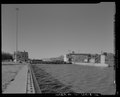
English: Peoria Lock and Dam, on the Illinois River at the south edge of Creve Coeur, just south of the Interstate 474 Shade-Lohmann Bridge, in Tazewell County, Illinois
| Object location | | View all coordinates using: OpenStreetMap |
|---|
|
This is a category about a place or building that is listed on the National Register of Historic Places in the United States of America. Its reference number is 04000169. |
lock and dam on the Illinois River in Creve Coeur, Illinois  | |||||
| Upload media | |||||
| Instance of | |||||
|---|---|---|---|---|---|
| Location | Creve Coeur, Tazewell County, Illinois | ||||
| Heritage designation |
| ||||
| Elevation above sea level |
| ||||
| Drainage basin |
| ||||
 | |||||
Media in category "Peoria Lock and Dam"
The following 31 files are in this category, out of 31 total.