Category:Pennine Way
Jump to navigation
Jump to search
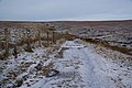
English: The Pennine Way is a hiking trail along the Pennine hills of Great Britain, passing through northern England into southern Scotland.
The traditional start of the Pennine Way is The Old Nags Head, Edale, and the traditional end point is Kirk_Yetholm, and the Border Hotel.
long distance footpath in England  | |||||
| Upload media | |||||
| Instance of |
| ||||
|---|---|---|---|---|---|
| Part of | |||||
| Location | Britain | ||||
| Highest point | |||||
| Terminus | |||||
 | |||||
Subcategories
This category has the following 9 subcategories, out of 9 total.
C
D
G
N
S
W
Media in category "Pennine Way"
The following 3 files are in this category, out of 3 total.
-
 Pennine way.png 1,112 × 4,968; 1.55 MB
-
 PennineWayRouteImage.svg 298 × 140; 8 KB
-
 The Pennine Bridleway about to cross Rams Clough - geograph.org.uk - 2201113.jpg 3,872 × 2,592; 1.81 MB

