Category:Pegwell Bay
Jump to navigation
Jump to search
bay on the coast of Kent, UK  | |||||
| Upload media | |||||
| Instance of | |||||
|---|---|---|---|---|---|
| Location |
| ||||
| Inflows | |||||
 | |||||
Subcategories
This category has the following 2 subcategories, out of 2 total.
H
- Hugin (ship, 1949) (39 F)
P
Media in category "Pegwell Bay"
The following 102 files are in this category, out of 102 total.
-

-
-
 Admiralty Chart No 1827 Plans on the South-East Coast of England, Published 1943.jpg 10,937 × 16,192; 50.95 MB
-
 Anti invasion cylinders, Pegwell Bay country park - geograph.org.uk - 4596780.jpg 2,272 × 1,704; 799 KB
-
 Approaches to Ramsgate cropped from Admiralty Chart No 1827, Published 1968.jpg 7,663 × 6,482; 11.35 MB
-
 Cafe at Pegwell Bay Nature Reserve - geograph.org.uk - 1600498.jpg 640 × 480; 139 KB
-
 Car park, Pegwell Bay Country Park - geograph.org.uk - 3094678.jpg 640 × 430; 64 KB
-
 Chalk Cliffs, Pegwell Bay - geograph.org.uk - 1546406.jpg 640 × 480; 142 KB
-
 Cliff Tops and Foreshore at Pegwell - geograph.org.uk - 29301.jpg 640 × 480; 72 KB
-
 Cliffs at Pegwell Bay, Thanet - geograph.org.uk - 727758.jpg 510 × 342; 170 KB
-
 Cliffs between Cliffsend and Ramsgate.jpg 3,748 × 2,648; 3.31 MB
-
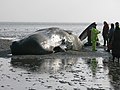
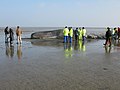
 Dead sperm whale at Pegwell Bay - geograph.org.uk - 2317513.jpg 2,000 × 1,500; 1.34 MB
-
-
 Dead whale on the mudflats at Pegwell Bay (geograph 2292237).jpg 640 × 480; 195 KB
-

-
 England Coast Path, Pegwell Bay Country Park - geograph.org.uk - 6395474.jpg 4,212 × 3,064; 1.94 MB
-
 England Coast Path, Pegwell Bay Country Park - geograph.org.uk - 6395477.jpg 4,565 × 2,914; 2.24 MB
-
 Flooded marshes, Pegwell Bay - geograph.org.uk - 3094687.jpg 640 × 430; 41 KB
-
 Footpath junction in Pegwell Bay Nature Reserve - geograph.org.uk - 2427781.jpg 3,072 × 2,304; 2.38 MB
-
 Gridsquare TR3663 at high tide - geograph.org.uk - 619011.jpg 640 × 480; 48 KB
-
 Hands & Molecule Sculpture - geograph.org.uk - 1938390.jpg 1,707 × 1,280; 379 KB
-
 Late afternoon over Pegwell Bay - geograph.org.uk - 728061.jpg 567 × 380; 142 KB
-
 Line of pillars at Pegwell Bay Country Park - geograph.org.uk - 3091456.jpg 3,872 × 2,592; 5.05 MB
-
 Looking out over Pegwell Bay - geograph.org.uk - 5670680.jpg 1,080 × 608; 228 KB
-
 Marker post, Shell Ness at high water - geograph.org.uk - 1587987.jpg 640 × 480; 194 KB
-
 Marshes, Pegwell Bay - geograph.org.uk - 3094693.jpg 640 × 430; 46 KB
-
 Marshes, Pegwell Bay - geograph.org.uk - 3097695.jpg 640 × 389; 36 KB
-
 Marshes, Pegwell Bay - geograph.org.uk - 3097700.jpg 640 × 430; 44 KB
-
 Marshes, Pegwell Bay NNR - geograph.org.uk - 3041990.jpg 640 × 430; 45 KB
-
 Marshland of Pegwell Bay - geograph.org.uk - 2358358.jpg 3,072 × 1,728; 1.63 MB
-
 Mudflats and chalk cliffs, Pegwell Bay - geograph.org.uk - 2153537.jpg 1,024 × 768; 215 KB
-
 Mudflats at Pegwell Bay - geograph.org.uk - 2317541.jpg 640 × 480; 185 KB
-
 National Trust Sign at Pegwell Bay - geograph.org.uk - 6395480.jpg 5,456 × 3,632; 4.57 MB
-
 Off-road cycle track at Pegwell Bay - geograph.org.uk - 1600506.jpg 640 × 480; 190 KB
-
 Pegwell Bay - geograph.org.uk - 1004244.jpg 640 × 481; 107 KB
-
 Pegwell Bay - geograph.org.uk - 2427692.jpg 3,072 × 1,728; 1.39 MB
-
 Pegwell Bay - geograph.org.uk - 3101687.jpg 640 × 430; 53 KB
-
 Pegwell Bay - geograph.org.uk - 3101694.jpg 640 × 430; 58 KB
-
 Pegwell Bay cliffs - geograph.org.uk - 983113.jpg 640 × 480; 33 KB
-
 Pegwell Bay Cliffs.JPG 3,072 × 2,304; 2.63 MB
-
 Pegwell Bay Country Park - geograph.org.uk - 1475024.jpg 640 × 480; 67 KB
-
 Pegwell Bay Country Park - geograph.org.uk - 3040165.jpg 640 × 430; 92 KB
-
 Pegwell Bay Country Park - geograph.org.uk - 3040167.jpg 640 × 430; 56 KB
-
 Pegwell Bay Country Park - geograph.org.uk - 3040170.jpg 640 × 430; 58 KB
-
 Pegwell Bay Country Park - geograph.org.uk - 3040173.jpg 640 × 430; 75 KB
-
 Pegwell Bay Country Park - geograph.org.uk - 3041981.jpg 640 × 430; 42 KB
-
 Pegwell Bay Country Park - geograph.org.uk - 3042009.jpg 640 × 430; 48 KB
-
 Pegwell Bay Country Park - geograph.org.uk - 6395470.jpg 5,456 × 3,632; 3 MB
-
 Pegwell Bay Country Park - geograph.org.uk - 6395473.jpg 4,405 × 2,893; 1.33 MB
-
 Pegwell Bay Dusk.jpg 3,072 × 2,304; 2.87 MB
-
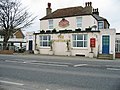
 Pegwell Bay Hotel - geograph.org.uk - 710737.jpg 640 × 438; 97 KB
-
 Pegwell Bay Hotel.jpg 3,072 × 2,304; 2.75 MB
-
 Pegwell Bay Information Board - geograph.org.uk - 2427882.jpg 3,072 × 2,304; 2.14 MB
-

-
 Pegwell Bay Marshes - geograph.org.uk - 3041996.jpg 640 × 430; 40 KB
-
 Pegwell Bay Marshes - geograph.org.uk - 3042003.jpg 640 × 430; 36 KB
-
 Pegwell Bay National Nature Reserve - geograph.org.uk - 3815328.jpg 4,000 × 3,000; 4.04 MB
-
 Pegwell Bay Nature Reserve - geograph.org.uk - 2427816.jpg 3,072 × 1,728; 2.08 MB
-
 Pegwell Bay near Ramsgate - geograph.org.uk - 3249938.jpg 1,500 × 1,000; 191 KB
-
 Pegwell Bay NNR - geograph.org.uk - 3041991.jpg 640 × 430; 42 KB
-
 Pegwell Bay NNR - geograph.org.uk - 3041994.jpg 640 × 430; 40 KB
-
 Pegwell Bay NNR - geograph.org.uk - 3042002.jpg 640 × 394; 42 KB
-
 Pegwell Bay, April 2021.jpg 5,067 × 3,801; 3.48 MB
-
 Pegwell Bay, Kent - geograph.org.uk - 684035.jpg 640 × 428; 234 KB
-

-
 Pegwell Country Park, lines of pillars - geograph.org.uk - 6018886.jpg 5,202 × 3,465; 3.87 MB
-
 Portakabin Hide, Pegwell Bay - geograph.org.uk - 2427800.jpg 3,072 × 2,304; 1.73 MB
-

-

-
 Regional Cycle Route 15 in Pegwell Bay Nature Reserve - geograph.org.uk - 2358283.jpg 3,072 × 2,304; 2.82 MB
-
 Regional Cycle Route 15 in Pegwell Bay Nature Reserve - geograph.org.uk - 2358296.jpg 3,072 × 2,304; 2.18 MB
-
 Regional Cycle Route 15 in Pegwell Bay Nature Reserve - geograph.org.uk - 2358314.jpg 3,072 × 2,304; 2.36 MB
-

-
 Salt Marsh, Pegwell Bay - geograph.org.uk - 3094664.jpg 640 × 394; 40 KB
-
 Salt Marsh, Pegwell Bay - geograph.org.uk - 3094665.jpg 640 × 430; 44 KB
-
 Salt Marsh, Pegwell Bay - geograph.org.uk - 3094667.jpg 640 × 430; 47 KB
-
 Salt Marsh, Pegwell Bay Country Park - geograph.org.uk - 3094670.jpg 640 × 430; 43 KB
-
 Salt Marsh, Pegwell Bay Country Park - geograph.org.uk - 3094672.jpg 640 × 430; 42 KB
-
 Salt Marsh, Pegwell Bay Country Park - geograph.org.uk - 3094675.jpg 640 × 430; 45 KB
-
 Salt Marsh, Pegwell Bay Country Park - geograph.org.uk - 3094679.jpg 640 × 402; 38 KB
-
 Salt Marsh, Pegwell Bay Country Park - geograph.org.uk - 3094680.jpg 640 × 430; 52 KB
-
 Salt Marsh, Pegwell Bay Country Park - geograph.org.uk - 3094684.jpg 640 × 430; 42 KB
-
 Salt marshes, Pegwell Bay - geograph.org.uk - 3042008.jpg 640 × 430; 44 KB
-
 Salty Seal Cafe, Pegwell Bay Country Park - geograph.org.uk - 6395515.jpg 5,456 × 3,632; 4.38 MB
-
 Sand bar at Shell Ness - geograph.org.uk - 1587994.jpg 640 × 480; 178 KB
-
 Shell Ness shortly after high tide - geograph.org.uk - 1587989.jpg 640 × 480; 207 KB
-
 Sun through cloud.JPG 3,072 × 2,304; 2.74 MB
-
 Sunset Pegwell.JPG 3,072 × 2,304; 3.08 MB
-
 The mud and sand of Pegwell Bay - geograph.org.uk - 1590688.jpg 640 × 480; 171 KB
-
 The stranded sperm whale at Pegwell Bay - geograph.org.uk - 2317507.jpg 640 × 480; 176 KB
-
 View across Pegwell Bay - geograph.org.uk - 3121993.jpg 1,044 × 783; 164 KB
-
 View across Pegwell Bay National Nature Reserve - geograph.org.uk - 3815330.jpg 4,000 × 3,000; 4.27 MB
-

-

-
 View of Pegwell Bay 2.JPG 3,072 × 2,304; 2.83 MB
-
 View of Pegwell Bay.JPG 2,560 × 1,920; 1.38 MB
-

-
 William Dyce 002.jpg 2,024 × 1,451; 380 KB
-
 World War II antitank cylinders at Pegwell Bay.jpg 1,500 × 782; 1.21 MB
-
 Looking SE from Pegwell picnic site. - geograph.org.uk - 315830.jpg 640 × 480; 206 KB
-
 Pegwell Bay Mudflats - geograph.org.uk - 39667.jpg 640 × 480; 86 KB
-


.jpg)


_-_geograph.org.uk_-_2358267.jpg)


