Category:Peak District Boundary Walk
Jump to navigation
Jump to search
Subcategories
This category has the following 2 subcategories, out of 2 total.
B
- Burbage Tunnel (7 F)
T
- Thirst House Cave (7 F)
Media in category "Peak District Boundary Walk"
The following 14 files are in this category, out of 14 total.
-
 Boundary stone - geograph.org.uk - 2331909.jpg 1,200 × 1,600; 470 KB
-
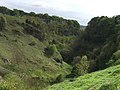 Deep Dale near Buxton.jpg 1,838 × 1,379; 1.04 MB
-
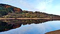 Fernilee Reservoir in the Goyt Valley.jpg 1,749 × 984; 619 KB
-
 Footpath to Holt Head, Lingards - geograph.org.uk - 4683252.jpg 2,048 × 1,536; 1,004 KB
-
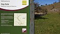 Hay Dale Nature Reserve Sign.jpg 1,854 × 1,043; 856 KB
-
 Hay Dale on Limestone Way.jpg 1,992 × 1,120; 1.39 MB
-
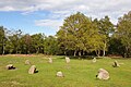 Nine Ladies Stone Circle on Stanton Moor.jpg 1,360 × 906; 697 KB
-
 Peak District Boundary Walk at Dam Dale.jpg 1,008 × 567; 276 KB
-
 Peak District Boundary Walk Marker.jpg 1,013 × 1,355; 447 KB
-
 Peak District Boundary Walk Plaque.jpg 1,027 × 1,027; 556 KB
-
 Serpentine Walks in Buxton.jpg 816 × 459; 286 KB
-
 Staden Low Enclosure.jpg 1,210 × 681; 333 KB
-
 Walkers Welcome waymark, Lingards - geograph.org.uk - 4683232.jpg 1,468 × 1,976; 826 KB
-
 White Nancy monument on Kerridge Hill in 2014.jpg 1,417 × 1,063; 613 KB


