Category:Pater-Philipp-Jeningen-Platz 2 (Eichstätt)
Jump to navigation
Jump to search
This is the category of the Bavarian Baudenkmal (cultural heritage monument) with the ID D-1-76-123-175 (Wikidata)
|
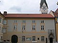
Deutsch: Pater-Philipp-Jeningen-Platz 2 Eichstätt: Ehemalige Domschule, dreigeschossiger Bau, 15. Jahrhundert, barockisiert, mit spätgotischem Portal zum Kreuzgang und Rundbogenportal des 17. Jahrhunderts.
| Object location | | View all coordinates using: OpenStreetMap |
|---|
 | |||||
| Upload media | |||||
| Instance of | |||||
|---|---|---|---|---|---|
| Location | Eichstätt, Upper Bavaria, Bavaria, Germany | ||||
| Street address |
| ||||
| Heritage designation | |||||
 | |||||
Subcategories
This category has only the following subcategory.
Media in category "Pater-Philipp-Jeningen-Platz 2 (Eichstätt)"
The following 5 files are in this category, out of 5 total.
-
 Pater-Philipp-Jeningen-Platz 2 Eichstätt.jpg 2,048 × 1,536; 843 KB
-
 Eichstätt Dom 02.jpg 1,280 × 960; 805 KB
-
 GER Eichstätt, Pater-Philipp-Jeningen-Platz 001.jpg 3,883 × 2,912; 1.43 MB
-
 GER Eichstätt, Pater-Philipp-Jeningen-Platz 002.jpg 3,024 × 4,032; 390 KB
-
 Pater-Philipp-Jeningen-Platz Eichstätt (2).jpg 2,048 × 1,536; 929 KB


.jpg)