Category:Pastorie St. Agatha (Lisse)
Jump to navigation
Jump to search
| Object location | | View all coordinates using: OpenStreetMap |
|---|
 | |||||
| Upload media | |||||
| Instance of | |||||
|---|---|---|---|---|---|
| Part of | |||||
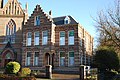
| Location | Lisse, South Holland, Netherlands | ||||
| Street address |
| ||||
| Located on street |
| ||||
| Heritage designation |
| ||||
 | |||||
|
This is a category about rijksmonument number 516103
|
| Address |
|
Media in category "Pastorie St. Agatha (Lisse)"
The following 2 files are in this category, out of 2 total.
-
 Overzicht pastorie - Lisse - 20140890 - RCE.jpg 3,052 × 3,076; 1.98 MB
-
 Pastorie Sint-Agathakerk - Lisse.JPG 3,872 × 2,592; 2.29 MB
