Category:Pastorie ('t Woudt)
Jump to navigation
Jump to search
| Object location | | View all coordinates using: OpenStreetMap |
|---|
 | |||||
| Upload media | |||||
| Instance of | |||||
|---|---|---|---|---|---|
| Location | Schipluiden, South Holland, Netherlands | ||||
| Street address |
| ||||
| Heritage designation |
| ||||
 | |||||
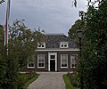
Nederlands: Nederlands Hervormde Pastorie
|
This is a category about rijksmonument number 33395
|
| Address |
|
Media in category "Pastorie ('t Woudt)"
The following 2 files are in this category, out of 2 total.
-
 Nederlands Hervormde Pastorie, voorgevel - 't Woudt - 20218290 - RCE.jpg 1,200 × 1,200; 481 KB
-
 Woudt10.jpg 3,024 × 2,532; 5.52 MB
