Category:Pastýřova hruška
Jump to navigation
Jump to search
| Object location | | View all coordinates using: OpenStreetMap |
|---|
memorable tree in Domažlice District, Czech Republic  | |||||
| Upload media | |||||
| Instance of |
| ||||
|---|---|---|---|---|---|
| Location | Únějovice, Domažlice District, Plzeň Region, Czechia | ||||
| Maintained by | |||||
| Height |
| ||||
 | |||||
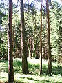
Čeština: Pastýřova hruška, památná hrušeň obecná (Pyrus communis) v lese nad obcí Únějovice, okres Domažlice. Odhadované stáří 600 let. U této údajně došlo k založení obce. Původně stála na planině, les kolem je náletový.
English: Pastýřova hruška (Shepherd's Pear), protected example of European Pear (Pyrus communis) in a forest above village of Únějovice, Domažlice District, Czech Republic. Estimated age 600 years.
Media in category "Pastýřova hruška"
The following 2 files are in this category, out of 2 total.
-
 Hruska.JPG 2,112 × 2,816; 1.04 MB
-
 Pastyrova Hruska. 10.05.2008.JPG 2,112 × 2,816; 1.04 MB
