Category:Parr Street bridge, St Helens
Jump to navigation
Jump to search
| Object location | | View all coordinates using: OpenStreetMap |
|---|
bridge in St Helens, Merseyside, England, United Kingdom  | |||||
| Upload media | |||||
| Instance of | |||||
|---|---|---|---|---|---|
| Location | St Helens, Merseyside, North West England, England | ||||
| Bridge number |
| ||||
| Crosses | |||||
 | |||||
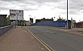
Bridge SBH1/37 carries Parr Street over the railway lines to the south of St Helens Central railway station. It is 5.11 miles from the datum at Huyton Junction. The ELR code SBH1=Huyton Junction to St Helens Station Junction.
Subcategories
This category has only the following subcategory.
P
Media in category "Parr Street bridge, St Helens"
The following 5 files are in this category, out of 5 total.
-
 Bridge at Parr Street, St Helens.JPG 4,320 × 3,240; 2.62 MB
-
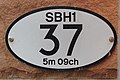 ID plate of Parr Street bridge, St Helens.jpg 5,198 × 3,462; 23.57 MB
-
 Parr Street bridge, St Helens 1.jpg 5,178 × 3,116; 20.07 MB
-
 Parr Street bridge, St Helens 2.jpg 5,192 × 3,221; 19.98 MB
-
 St Helens Central from Parr Street bridge, St Helens.jpg 5,030 × 2,701; 17.4 MB


