Category:Parkgate bathouse
Jump to navigation
Jump to search
| Object location | | View all coordinates using: OpenStreetMap |
|---|
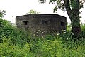
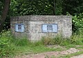
Former World War II pillbox on the former site of Parkgate railway station, converted into a nesting box for bats.
Media in category "Parkgate bathouse"
The following 6 files are in this category, out of 6 total.
-
 Parkgate bathouse 1.jpg 5,184 × 3,456; 16.27 MB
-
 Parkgate bathouse 2.jpg 4,680 × 3,276; 11.44 MB
-
 Pillbox at Station Road, Parkgate.JPG 4,320 × 3,240; 5.93 MB
-
 World War II Pill box, at Neston - geograph.org.uk - 679254.jpg 640 × 480; 148 KB
-
 WWII pillbox and footpath - geograph.org.uk - 1137982.jpg 640 × 480; 185 KB
-
 WWII pillbox at Parkgate - geograph.org.uk - 1137977.jpg 640 × 480; 206 KB


