Category:Park dworski w Makowlanach
Jump to navigation
Jump to search
| Object location | | View all coordinates using: OpenStreetMap |
|---|
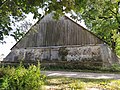
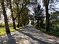
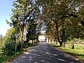
park in Makowlany, Poland  | |||||
| Upload media | |||||
| Instance of | |||||
|---|---|---|---|---|---|
| Location | Makowlany, Gmina Sidra, Sokółka County, Podlaskie Voivodeship, Poland | ||||
| Heritage designation |
| ||||
| Inception |
| ||||
 | |||||
Media in category "Park dworski w Makowlanach"
The following 17 files are in this category, out of 17 total.
-
 Makowlany park dworski 01.jpg 4,000 × 3,000; 8.02 MB
-
 Makowlany park dworski 02.jpg 4,000 × 3,000; 7.77 MB
-
 Makowlany park dworski 03.jpg 4,000 × 3,000; 8.98 MB
-
 Makowlany park dworski 04.jpg 4,000 × 3,000; 10.04 MB
-
 Makowlany park dworski 05.jpg 4,000 × 3,000; 10.2 MB
-
 Makowlany park dworski 06.jpg 4,000 × 3,000; 10.68 MB
-
 Makowlany park dworski 07.jpg 4,000 × 3,000; 9.17 MB
-
 Makowlany park dworski 08.jpg 4,000 × 3,000; 8.93 MB
-
 Makowlany park dworski 09.jpg 4,000 × 3,000; 10.73 MB
-
 Makowlany park dworski 10.jpg 4,000 × 3,000; 10.59 MB
-
 Makowlany park dworski 11.jpg 4,000 × 3,000; 10.12 MB
-
 Makowlany park dworski 12.jpg 4,000 × 3,000; 9.6 MB
-
 Makowlany park dworski 13.jpg 4,000 × 3,000; 9.66 MB
-
 Makowlany park dworski 14.jpg 3,000 × 4,000; 10.37 MB
-
 Makowlany park dworski 15.jpg 4,000 × 3,000; 8.95 MB
-
 Makowlany park dworski 16.jpg 4,000 × 3,000; 9.08 MB
-
 Makowlany park dworski 17.jpg 4,000 × 3,000; 9.81 MB


