Category:Park Meineweh
Jump to navigation
Jump to search
| Object location | | View all coordinates using: OpenStreetMap |
|---|
Protected landscape element in Meineweh Municipality, Saxony-Anhalt  | |||||
| Upload media | |||||
| Instance of | |||||
|---|---|---|---|---|---|
| Location | Q1918073, Meineweh, Wethautal, Burgenlandkreis, Saxony-Anhalt, Germany | ||||
| Heritage designation | |||||
| Inception |
| ||||
 | |||||
Media in category "Park Meineweh"
The following 10 files are in this category, out of 10 total.
-
 Meineweh, autumn in the park.jpg 2,657 × 1,772; 1.65 MB
-
 Park Meineweh - Ansicht am östlichen Weg.jpg 3,024 × 4,032; 9.47 MB
-
 Park Meineweh - Ansicht mittlerer Weg.jpg 4,032 × 3,024; 8.7 MB
-
 Park Meineweh - Baumgruppe und Mauer am westlichen Weg.jpg 3,024 × 4,032; 7.15 MB
-
 Park Meineweh - Blick auf Rückseite Wohnhaus.jpg 4,032 × 3,024; 8.01 MB
-
 Park Meineweh - Blick auf Scheune am Rittergut und Südeingang.jpg 4,032 × 3,024; 7.67 MB
-
 Park Meineweh - Mittelweg mit Blick auf ehemaliges Rittergut.jpg 4,032 × 3,024; 8.23 MB
-
 Park Meineweh - Parkansicht am Mittelweg.jpg 3,024 × 4,032; 8.69 MB
-
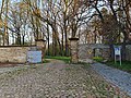 Park Meineweh - südlicher Eingang mit Schild.jpg 4,032 × 3,024; 8.3 MB
-
 Park Meineweh - westlicher Eingang mit Schild.jpg 4,032 × 3,024; 6.77 MB


