Category:Parish church of St. Pauls, South Tyrol
Jump to navigation
Jump to search
| Object location | | View all coordinates using: OpenStreetMap |
|---|
church building in St. Pauls, Eppan, South Tyrol, Italy .jpg) | |||||
| Upload media | |||||
| Instance of | |||||
|---|---|---|---|---|---|
| Named after | |||||
| Dedicated to | |||||
| Location | St. Pauls, Eppan an der Weinstraße, South Tyrol, Trentino-South Tyrol, Italy | ||||
| Architectural style | |||||
| Diocese | |||||
| Heritage designation | |||||
| Religion or worldview | |||||
| official website | |||||
 | |||||
| This category shows the cultural heritage monument with the number 14697 in South Tyrol. (Wikidata)
|
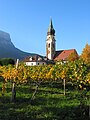
Deutsch: Pfarrkirche St. Pauli Bekehrung von St. Pauls in der Gemeinde Eppan, auch der "Dom auf dem Lande" genannt, Höhe 86m, erbaut zwischen 1460 und 1552
English: St. Pauls Church, Eppan (it: Appiano), South Tyrol - height 86m - built from 1460 til 1552
Italiano: Chiesa di S. Paolo in Appiano (ted: Eppan), Alto Adige - altezza 86m - costruito tra 1460-1552
Subcategories
This category has the following 2 subcategories, out of 2 total.
Media in category "Parish church of St. Pauls, South Tyrol"
The following 23 files are in this category, out of 23 total.
-
 Eppan Kirche in St. Pauls.jpg 3,264 × 2,448; 3.23 MB
-
 Eppan Kirchentür in St. Pauls.jpg 3,264 × 2,448; 3.41 MB
-
 Eppan sankt paul.JPG 1,200 × 1,600; 555 KB
-
 Eppan St. Pauls Epitaph Christoph Vinschgau zu Altenburg 1600.jpg 3,030 × 3,999; 4.6 MB
-
 Eppan St. Pauls Epitaph Hans Grasmann gest. 1509.jpg 3,456 × 5,184; 6.09 MB
-
 Eppan St. Pauls Epitaph Magdalena Kaßler von Boymont gest. 1523.jpg 3,429 × 5,145; 5.44 MB
-
 Eppan St. Pauls Pfarrkirche Grab Josef Daney I.jpg 3,456 × 5,184; 7.37 MB
-
 Eppan St. Pauls Pfarrkirche Grab Josef Daney II.jpg 3,456 × 5,184; 5.01 MB
-
 MZK 02 Reisebericht über einige Denkmale.pdf 1,181 × 1,625, 6 pages; 325 KB
-
 Pfarrkirche St. Pauls - Infotafel.JPG 3,096 × 4,161; 4.91 MB
-
 Pfarrkirche St. Pauls - Südeingang.JPG 3,308 × 5,088; 6.42 MB
-
 Pfarrkirche St. Pauls Sonnenuhr an der Sakristei.JPG 5,184 × 3,456; 5.86 MB
-
 Pfarrkirche St. Pauls, Eppan (Nord-West).jpg 2,608 × 3,920; 5.29 MB
-
 San Paolo, chiesa della Conversione di San Paolo 01.jpg 3,888 × 5,184; 5.09 MB
-
 San Paolo, chiesa della Conversione di San Paolo 02.jpg 5,184 × 3,888; 5.78 MB
-
 Seitenportal St. Pauli Bekehrung St. Pauls Eppan-1.jpg 4,266 × 3,426; 1.96 MB
-
 St. Pauli Bekehrung St. Pauls Eppan-1.jpg 3,346 × 5,236; 2.06 MB
-
 St. Pauls - St. Paulus - 01.jpg 3,480 × 2,386; 1.72 MB
-
 St. Pauls - St. Paulus - 10.jpg 3,063 × 2,475; 2.03 MB
-
 St. Pauls - St. Paulus - 11.jpg 3,309 × 2,592; 2.31 MB
-
 St. Pauls - St. Paulus - 12.jpg 3,888 × 2,592; 3.14 MB
-
 St. Pauls Brunnen.jpg 3,264 × 2,448; 3.56 MB
-
 St. Pauls Korb.JPG 2,592 × 1,944; 1.2 MB


