Category:Paria Plateau
Jump to navigation
Jump to search

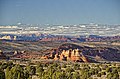
English: The Paria Plateau — a plateau in northern Arizona.
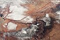
- Located on the eastern North Rim of the Grand Canyon — adjacent to the east of the Kaibab Plateau.
- Within the High Plateaus physiographic section of the Colorado Plateau physiographic province.
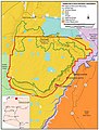
- The Vermilion Cliffs National Monument and Paria Canyon-Vermilion Cliffs Wilderness are on the Paria Plateau.
Subcategories
This category has the following 6 subcategories, out of 6 total.
H
P
V
Media in category "Paria Plateau"
The following 17 files are in this category, out of 17 total.
-
-
 Grand Canyon satelliet.jpg 2,600 × 2,000; 1,004 KB
-
 GrandCanyon.NASA.2014.jpg 1,440 × 960; 612 KB
-
 House Rock Valley Between Paria and Kiabab Plateaus, Arizona (6780631597).jpg 4,000 × 3,000; 5.36 MB
-
 ISS-39 Grand Canyon.jpg 4,256 × 2,832; 4 MB
-
 ISS058-E-1605 Grand Canyon Under Snow.jpeg 5,568 × 3,712; 5.3 MB
-
 Map of Arizona NA.png 2,122 × 1,640; 2.25 MB
-
 Marble Canyon Between Paria and Kaibito Plateaus, Arizona (6780632027).jpg 4,000 × 3,000; 5.37 MB
-
 Marble Canyon Between Paria and Kaibito Plateaus, Arizona (6780632791).jpg 4,000 × 3,000; 5.34 MB
-
 National-atlas-arizona.png 764 × 588; 136 KB
-
 Paria Canyon, Utah-Arizona Border, Near Page, Arizona (7235101964).jpg 4,000 × 3,000; 7.8 MB
-
 Paria Canyon, Utah-Arizona Border, Near Page, Arizona (7235102916).jpg 4,000 × 3,000; 7.24 MB
-

-
 Satellite image of the Grand Canyon.jpeg 1,219 × 947; 299 KB
-
 Sunrise at Cottonwood Cove (8182412209).jpg 5,616 × 3,844; 6.46 MB
-
 VermilionCliffsComposite5695.jpg 4,950 × 860; 2.67 MB
-
 VermilionCliffsMap.jpg 500 × 658; 62 KB


.jpg)


.jpg)
.jpg)

.jpg)
.jpg)
.png)

.jpg)
