Category:Panoramics of mountains in New Zealand
Jump to navigation
Jump to search
Media in category "Panoramics of mountains in New Zealand"
The following 68 files are in this category, out of 68 total.
-
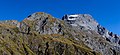
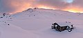 Angelus Hut in the winter, Nelson Lakes National Park, New Zealand.jpg 7,357 × 3,437; 5.13 MB
-
 Blue mountain tops NZ.jpg 8,919 × 1,751; 4.38 MB
-
 Browning Range during winter sunrise, Lake Kaniere Scenic Reserve, West Coast, New Zealand.jpg 13,814 × 4,707; 35.29 MB
-
 Canterbury, South Island banner 2.jpg 14,209 × 2,027; 19.11 MB
-
 Canterbury, South Island banner 3.jpg 10,003 × 1,431; 11.2 MB
-
 Carex secta on Lake Clearwater, Canterbury, New Zealand.jpg 14,843 × 4,567; 52.53 MB
-
 Cass Saddle, Craigieburn Forest Park, New Zealand.jpg 11,737 × 3,551; 31.69 MB
-
 Fog around Lake Heron, Taylor Range, Canterbury, New Zealand.jpg 16,968 × 3,467; 26.18 MB
-
 Freyberg Range & Spenser Mts 06.jpg 6,521 × 1,839; 7.19 MB
-
 Hakatere River valley, Canterbury, New Zealand.jpg 11,155 × 3,279; 19.82 MB
-
 Hills in Lindis Pass, New Zealand.jpg 10,014 × 4,156; 17.42 MB
-
 Lake Benmore with surrounding hills, New Zealand 01.jpg 12,107 × 3,945; 21.06 MB
-
 Lake Benmore with surrounding hills, New Zealand 02.jpg 11,904 × 3,370; 14.23 MB
-
 Lake Benmore, New Zealand.jpg 11,585 × 3,027; 22.22 MB
-
 Lake Clearwater, Canterbury, New Zealand 15.jpg 12,162 × 3,411; 22.83 MB
-
 Lake Dunstan - Clutha Arm (panorama).jpg 7,952 × 1,920; 15.97 MB
-
 Lake Dunstan - Dunstan Arm (panorama).jpg 8,176 × 1,920; 14.97 MB
-
 Lake Pukaki, Canterbury, New Zealand.jpg 16,887 × 3,760; 20.66 MB
-
 Lake Waikaremoana.jpg 6,490 × 1,384; 1.43 MB
-
 Landscape close to Dun Saddle, Bryant Range, New Zealand.jpg 19,267 × 3,285; 35.69 MB
-
 Lewis Pass, New Zealand (panorama).jpg 8,000 × 1,920; 15.13 MB
-
 Lyttelton Harbour (Whakaraupō) from Mt Ada, Canterbury, New Zealand.jpg 20,088 × 4,692; 71.05 MB
-
 Main Divide from Yeats Ridge Hut, West Coast Region, New Zealand.jpg 7,386 × 2,902; 14.42 MB
-
 Makarora River, Otago, New Zealand.jpg 15,351 × 3,174; 26.79 MB
-
 Maniniaro - Angelus Peak, Nelson Lakes National Park, New Zealand.jpg 19,835 × 5,127; 41.48 MB
-
 Milford Sound.jpg 15,456 × 1,768; 5.13 MB
-
 Morning clouds in Hakatere Conservation Park, Canterbury, New Zealand.jpg 9,543 × 2,599; 8.12 MB
-
 Mt Awful, Gillespie Pass, New Zealand 02.jpg 10,531 × 4,861; 32.07 MB
-
 Mt Bruce (left), Lagoon Saddle and Mid Hill (right), Black Range, Canterbury, New Zealand.jpg 17,264 × 4,842; 64.84 MB
-
 Mt Sefton massif, Aoraki - Mount Cook National Park, New Zealand.jpg 8,699 × 3,034; 17.34 MB
-
 Mt Somers Range from Mt Taylor.jpg 10,578 × 4,510; 31.36 MB
-
 Mueller Hut with Mt Sefton and Aoraki (Mt Cook) during the sunrise.jpg 15,342 × 3,722; 34.72 MB
-
 Mystery Lake and Two Thumb Range, Canterbury, New Zealand.jpg 12,836 × 4,336; 33.64 MB
-
 New Zealand Milford Sound 2005-01-27.jpg 6,008 × 1,404; 1.25 MB
-
 Northern part of Lake Wanaka with surrounding mountains, New Zealand.jpg 14,714 × 2,740; 15.61 MB
-
 Panorama of Hinewai Reserve, Banks Peninsula, New Zealand 02.jpg 18,040 × 4,840; 55.83 MB
-
 Panorama of Hinewai Reserve, Banks Peninsula, New Zealand.jpg 15,517 × 2,512; 24.68 MB
-
 Panoramic mountain view from the Routeburn Track.jpg 5,542 × 894; 2.29 MB
-
 Panoramic View of Mt. Oxford Summit, North Canterbury, New Zealand (7900186690).jpg 8,192 × 1,856; 8.48 MB
-

-
 Porters Pass with Big Ben Range, Torlesse Range, New Zealand.jpg 13,666 × 3,484; 31.31 MB
-
 Remarkables 2.jpg 14,443 × 2,178; 4.46 MB
-
 Routeburn Track banner Panoramic Mountain View.jpg 4,905 × 701; 1.64 MB
-
 Seaward Kaikoura Range (view from SH 1).jpg 4,000 × 1,000; 3.96 MB
-
 South Island new banner 1.jpg 12,150 × 1,739; 9.7 MB
-
 Southern Alps from Hamilton Peak.jpg 14,742 × 1,710; 6.09 MB
-
 Sun over Lake Hawea, New Zealand.jpg 7,784 × 3,236; 7.16 MB
-
 Sunrise over Benmore Range, New Zealand.jpg 11,647 × 2,412; 9.69 MB
-
 Sunrise over Lake Wanaka from Boundary Creek, New Zealand.jpg 11,944 × 3,536; 28.72 MB
-
 Tasman Lake panorama (03-05-06-07).jpg 6,960 × 2,250; 9.84 MB
-
 Torlesse Range from Mt Torlesse, New Zealand.jpg 11,968 × 3,181; 21.03 MB
-
 Torlesse Ranges, Southern Alps, New Zealand.jpg 3,000 × 596; 2.37 MB
-
 Travis Wetland panorama, Christchurch, New Zealand.jpg 22,032 × 3,387; 50.33 MB
-
 Two Thumb Range, Canterbury, New Zealand 02.jpg 5,167 × 2,000; 7.44 MB
-
 View from Foggy Peak to Castle Hill Peak, Torlesse Range, New Zealand.jpg 15,108 × 3,183; 19.79 MB
-
 View from Foggy Peak to Craigieburn Range, New Zealand.jpg 14,209 × 2,979; 21.89 MB
-
 View from Foggy Peak to Lake Lyndon, New Zealand.jpg 11,912 × 3,294; 23.94 MB
-
 View from Isthmus Peak Trail to Lake Hawea, New Zealand 03.jpg 12,681 × 3,393; 21.61 MB
-
 View from Mt Oxford, Oxford Forest Conservation Area, Canterbury, New Zealand.jpg 10,003 × 3,292; 22.02 MB
-
 View north from Mt Richardson, New Zealand.jpg 15,821 × 2,843; 32.96 MB
-
 View of Robert Ridge Route in the winter, Nelson Lakes National Park, New Zealand.jpg 10,246 × 3,416; 15.24 MB
-
 View towards Garnet Peak from Mons Sex Millia, New Zealand.jpg 13,946 × 4,402; 43.99 MB
-
 View towards Gillespie Valley from Gillespie Pass, New Zealand 10.jpg 9,562 × 3,251; 22.73 MB
-
 View towards Gillespie Valley from Gillespie Pass, New Zealand 12.jpg 11,087 × 2,807; 20.42 MB
-
 View towards Mons Sex Millia from Garnet Peak, New Zealand.jpg 14,455 × 4,428; 54.04 MB
-
 Wanaka pan.jpg 6,723 × 1,439; 1.3 MB
-
 Wilkin River close to its confluence with Makarora River, New Zealand.jpg 6,195 × 2,985; 10.19 MB
-
 Wilkin River close to its confluence with Makarora River, Otago, New Zealand.jpg 8,324 × 3,532; 19.91 MB


.jpg)
.jpg)
.jpg)
_from_Mt_Ada,_Canterbury,_New_Zealand.jpg)
,_Lagoon_Saddle_and_Mid_Hill_(right),_Black_Range,_Canterbury,_New_Zealand.jpg)
_during_the_sunrise.jpg)
.jpg)
.jpg)
.jpg)