Category:Pak Sha Toi Fat Tong
Jump to navigation
Jump to search
| Object location | | View all coordinates using: OpenStreetMap |
|---|
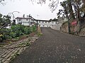
English: Pak Sha Toi Fat Tong. Buddhist temple. No.3 Mang Kung Wo Road, Tai Chung Hau, Hebe Haven.
中文:白沙台佛堂 or 白沙臺佛堂
Media in category "Pak Sha Toi Fat Tong"
The following 2 files are in this category, out of 2 total.
-
 Pak Sha Toi Fat Tong 01.jpg 4,160 × 3,120; 5.51 MB
-
 Pak Sha Toi Fat Tong 02.jpg 4,160 × 3,120; 5.96 MB

