Category:Pafuri
Jump to navigation
Jump to search
Afrikaans: Pafoerie, in die noordelike Nasionale Krugerwildtuin, word aan die noord- en suidekant deur onderskeidelik die Limpopo- en Levoeboeriviere begrens.
English: The far northern section of the Kruger National Park, flanked by the Limpopo and Levubu/Luvhuvhu rivers. Recently also known as Makuleke.
Conservation region in Kruger National Park  | |||||
| Upload media | |||||
| Instance of | |||||
|---|---|---|---|---|---|
| Location | Limpopo, Transvaal region | ||||
| IUCN protected areas category | |||||
 | |||||
Subcategories
This category has the following 8 subcategories, out of 8 total.
- Flora of Pafuri (48 F)
C
- Crooks Corner (18 F)
L
- Lanner Gorge (4 F)
P
- Pafuri nickel Deposit (1 F)
- Pafuri picnic site (15 F)
T
- Thulamela (3 F)
Media in category "Pafuri"
The following 13 files are in this category, out of 13 total.
-
 001032-asteroid shape model (1032) Pafuri.png 250 × 250; 17 KB
-
 Crook's corner.jpg 2,048 × 1,536; 346 KB
-
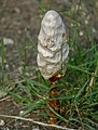 Desert Shaggymane (Podaxis pistillaris) (52776786616).jpg 3,648 × 4,830; 3.21 MB
-
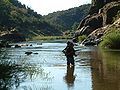
 Kenneth Creamer Pafuri 2017.jpg 4,032 × 3,024; 2.45 MB
-
 Kruger Park - Pafuri picnic area - 001.JPG 3,888 × 2,592; 6.55 MB
-
 Kruger Park - Pafuri picnic area - 002.JPG 3,888 × 2,592; 5.68 MB
-
 Lanner Gorge Pafuri.jpg 2,032 × 1,524; 401 KB
-
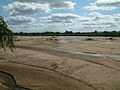
 Luvuvhu crossing.jpg 2,048 × 1,536; 393 KB
-
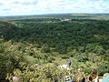 Makuleke1.JPG 2,048 × 1,536; 563 KB
-
 Makuleke4.JPG 2,048 × 1,536; 555 KB
-
 Makuleke5.JPG 2,048 × 1,536; 520 KB
-
 Pafuri Gate (North Entrance Kruger Park).jpg 2,592 × 1,944; 3.48 MB
-
 Pafuri.png 3,000 × 2,052; 23.51 MB
_Pafuri.png)

_(52776786616).jpg)


.jpg)
