Category:Pack- und Stubalpe
Jump to navigation
Jump to search
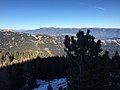
Deutsch: Die Pack- und Stubalpe ist ein bis zu 2.187 m hohes Berggebiet, das in der Steiermark und Kärnten in Österreich liegt.
mountain range in the Lavantal Alps | |||||
| Upload media | |||||
| Instance of |
| ||||
|---|---|---|---|---|---|
| Location |
| ||||
| Mountain range |
| ||||
| Highest point | |||||
 | |||||
Subcategories
This category has the following 6 subcategories, out of 6 total.
H
- Hirzmann-Stausee (29 F)
L
- Langmann-Stausee (16 F)
P
- Packer Stausee (15 F)
S
- Salzstiegelhaus (1 F)
Media in category "Pack- und Stubalpe"
The following 11 files are in this category, out of 11 total.
-
 2022-04-21 StMareinFeistritz Wasserleith Packalpe.jpg 5,544 × 2,356; 1.64 MB
-
 Autobahnbrücke A2 im Packabschnitt in Auerling, Gemeinde Preitenegg, Kärnten.jpg 1,500 × 943; 1.31 MB
-
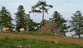 Felsen Knödelhütte 03, Oberauerling, Lavanttal, Kärnten.jpg 1,466 × 837; 761 KB
-
 Gemeinde Hüttenberg, Austria - panoramio (5).jpg 3,264 × 2,448; 2.03 MB
-
 Hirschegger.jpg 640 × 480; 112 KB
-
 Knödelhütte 01, Oberauerling, Lavanttal, Kärnten.jpg 1,500 × 968; 904 KB
-
 Knödelhütte 02, Oberauerling, Lavanttal, Kärnten.jpg 1,442 × 864; 706 KB
-
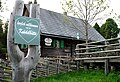 Knödelhütte, Oberauerling, Lavanttal, Kärnten.jpg 1,448 × 989; 935 KB
-
 Obdacher Sattel.jpg 3,648 × 2,736; 2.82 MB
-
 Oberallach, Gemeinde Trebesing mit Blick ins Liesertal, Kärnten.jpg 1,500 × 926; 1.49 MB
-
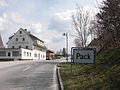 Packsattel.jpg 640 × 480; 123 KB


.jpg)


