Category:PNG maps of Alcalá de Henares
Jump to navigation
Jump to search
Media in category "PNG maps of Alcalá de Henares"
The following 35 files are in this category, out of 35 total.
-

-
 Alcalá de Henares (1938-1939) mapa topográfico 560 del Ejército del Centro - EM.png 5,079 × 6,578; 38.87 MB
-
 Alcalá de Henares (20-07-1837) croquis de Pedro Ortiz de Pinedo.png 4,893 × 3,340; 20.93 MB
-
 Alcalá de Henares (20-10-1802) plano topográfico del Soto de Aldovea.png 7,649 × 4,891; 62.07 MB
-
 Alcalá de Henares (2011) Corredor Eco Fluvial del río Henares.png 727 × 493; 626 KB
-
 Alcalá de Henares (2020) vías pecuarias, mapa.png 1,242 × 1,365; 3.88 MB
-
 Alcalá de Henares (2024) mapa del término municipal.png 1,183 × 684; 176 KB
-

-
 Alcalá de Henares (RPS 07-03-2020) Parque de los Cerros, mapa.png 2,607 × 2,289; 5 MB
-
 Alcalá de Henares (RPS 24-06-2018) Barrios durante la Edad Media, plano.png 1,278 × 681; 904 KB
-
 Alcalá de Henares (RPS 27-03-2016) Parque de Los Cerros, mapa.png 2,127 × 1,919; 3.34 MB
-
 Alcalá de Henares (s. XVI y XVII) plano con los edificios principales.png 1,822 × 1,301; 3.68 MB
-
 Alcalá de Henares, casco histórico, calle Mayor.png 1,007 × 751; 149 KB
-
 Alcalá de Henares, casco histórico.png 1,007 × 751; 146 KB
-

-
 Ciudad Universitaria de Cisneros (Juan de Ovando 1564) plano de 1768.png 2,401 × 3,137; 16.69 MB
-
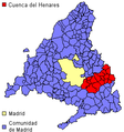
 Comarca de Alcala-mapa.png 283 × 396; 16 KB
-
 Comarca forestal 6 de la Comunidad de Madrid (2007) Alcalá de Henares, mapa.png 1,617 × 2,306; 802 KB
-
 Comarca henares.png 284 × 303; 11 KB
-
 Diocesis de Alcala.PNG 226 × 435; 7 KB
-
 Diocesisdealcalá.PNG 534 × 373; 16 KB
-
 Diócesis de Alcalá.PNG 534 × 373; 11 KB
-
 Emilio Valverde (1886) Plano de Alcalá de Henares.png 2,496 × 1,232; 5.41 MB
-
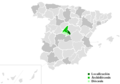
 España - Comunidad de Madrid - Alcalá de Henares.png 283 × 396; 15 KB
-
 Francisco Coello (1853) Provincia de Madrid, plano de Alcalá de Henares.png 1,443 × 1,106; 4.13 MB
-
 Guía del Viajero en España y Portugal (1887) plano de Alcalá de Henares.png 1,118 × 862; 2.2 MB
-
 Karte Gemeinde Alcalá de Henares 2022.png 5,000 × 5,367; 2.77 MB
-
 Localización de Alcala de Henares.PNG 315 × 387; 37 KB
-
 Mapa Alcala.PNG 226 × 435; 8 KB
-

-

-
 Real Jardín Botánico Juan Carlos I (RPS 07-06-2014) plano general.png 2,526 × 1,211; 5.28 MB
-
 Real Jardín Botánico Juan Carlos I (RPS 23-02-2019) comarcas en el parque regional.png 2,259 × 1,793; 7.37 MB
-
 Soto del Henares (2000) distribución geográfica, mapa.png 1,636 × 1,480; 464 KB
-
 Universidad de Alcalá (RPS 25-11-2017) Campus Científico-tecnológico, cartel.png 2,224 × 1,627; 5.35 MB
_plano_de_los_pisos_bajo_y_principal_del_Colegio_de_los_Manriques.png)
_mapa_topogr%C3%A1fico_560_del_Ej%C3%A9rcito_del_Centro_-_EM.png)
_croquis_de_Pedro_Ortiz_de_Pinedo.png)
_plano_topogr%C3%A1fico_del_Soto_de_Aldovea.png)
_Corredor_Eco_Fluvial_del_r%C3%ADo_Henares.png)
_v%C3%ADas_pecuarias,_mapa.png)
_mapa_del_t%C3%A9rmino_municipal.png)
_planta_exterior_del_Colegio_de_Artiller%C3%ADa.png)
_Parque_de_los_Cerros,_mapa.png)
_Barrios_durante_la_Edad_Media,_plano.png)
_Parque_de_Los_Cerros,_mapa.png)
_plano_con_los_edificios_principales.png)


_cartel_con_el_plano_de_distribuci%C3%B3n.png)
_plano_de_1768.png)

_Alcal%C3%A1_de_Henares,_mapa.png)


_Plano_de_Alcal%C3%A1_de_Henares.png)

_Provincia_de_Madrid,_plano_de_Alcal%C3%A1_de_Henares.png)
_plano_de_Alcal%C3%A1_de_Henares.png)


_cartel_del_plano_de_distribuci%C3%B3n_de_las_cepas.png)
_plano_general.png)
_comarcas_en_el_parque_regional.png)
_distribuci%C3%B3n_geogr%C3%A1fica,_mapa.png)
_Campus_Cient%C3%ADfico-tecnol%C3%B3gico,_cartel.png)
_proyecto_de_canal_de_regad%C3%ADo.png)