Category:Påbo kapell
Jump to navigation
Jump to search
| Object location | | View all coordinates using: OpenStreetMap |
|---|
 | |||||
| Upload media | |||||
| Instance of | |||||
|---|---|---|---|---|---|
| Location | Ulricehamn Municipality, Västra Götaland County, Sweden | ||||
| Diocese | |||||
 | |||||
|
This is a category about an ecclesiastical monument in Sweden, number 21300000003213 (sub-number: 21400000443870) in the RAÄ buildings database.
|
Media in category "Påbo kapell"
The following 4 files are in this category, out of 4 total.
-
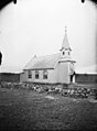 Gällstad, Påbo kapell - KMB - 16000200164033.jpg 441 × 600; 43 KB
-
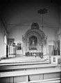 Gällstad, Påbo kapell - KMB - 16000200164034.jpg 443 × 600; 38 KB
-
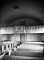 Gällstad, Påbo kapell - KMB - 16000200164035.jpg 441 × 600; 39 KB
-
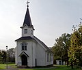 Påbo kapell.jpg 2,932 × 2,512; 2.94 MB


Categories:
- Built in Ulricehamn Municipality in 1923
- Churches in the Diocese of Skara
- Churches in Ulricehamn Municipality
- Churches in Västergötland
- Churches in Sweden built in 1923
- Listed churches in Ulricehamn Municipality
- Wooden buildings in Västergötland
- Wooden churches in Västra Götaland County
- White churches in Sweden