Category:Out Skerries Lighthouse
Jump to navigation
Jump to search
| Object location | | View all coordinates using: OpenStreetMap |
|---|
|
This is a category about listed building number 19894. |
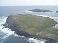
lighthouse on Bound Skerry, Shetland, Scotland, UK  Bound Skerry Lighthouse in 2009 | |||||
| Upload media | |||||
| Instance of | |||||
|---|---|---|---|---|---|
| Made from material | |||||
| Location |
| ||||
| Operator | |||||
| Heritage designation |
| ||||
| Inception |
| ||||
| Significant event |
| ||||
| Height |
| ||||
| Replaces |
| ||||
 | |||||
Media in category "Out Skerries Lighthouse"
The following 10 files are in this category, out of 10 total.
-
-
 Bound Skerry Lighthouse - geograph.org.uk - 1409555.jpg 480 × 640; 44 KB
-
 Bound Skerry Lighthouse - geograph.org.uk - 1971657.jpg 768 × 472; 354 KB
-
 Bound Skerry Lighthouse from the Out Skerries Ferry - geograph.org.uk - 3935730.jpg 1,400 × 1,050; 360 KB
-
 Grunay.jpg 455 × 341; 40 KB
-
 Lighthouse on Bound Skerry - geograph.org.uk - 749210.jpg 640 × 480; 49 KB
-
 Lighthouse on Bound Skerry, Out Skerries - geograph.org.uk - 5795830.jpg 1,600 × 1,065; 362 KB
-

-
 Out Skerries- Bound Skerry from Bruray Ward (geograph 3651372).jpg 640 × 480; 61 KB
-
 Out Skerries- Bound Skerry lighthouse (geograph 3651374).jpg 480 × 640; 56 KB


.jpg)
.jpg)
Categories:
- Bound Skerry
- Lighthouses in the Shetland Islands
- 1850s lighthouses in the United Kingdom
- Built in Scotland in 1858
- Lighthouses built in 1858
- Lighthouses built by Stevenson family
- Lighthouses in Scotland by name
- Lighthouses by height, 21 to 30 meters
- Lighthouses by range, 20 to 24 nm
- Landfall lights in the United Kingdom