Category:Ouderhoek
Jump to navigation
Jump to search
| Object location | | View all coordinates using: OpenStreetMap |
|---|
 | |||||
| Upload media | |||||
| Instance of |
| ||||
|---|---|---|---|---|---|
| Location | Nieuwersluis, Stichtse Vecht, Utrecht, Netherlands | ||||
| Street address |
| ||||
| Heritage designation |
| ||||
| Date of official opening |
| ||||
| Date of official closure |
| ||||
 | |||||
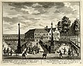
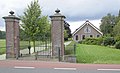
Nederlands: Ouderhoek was een buitenplaats langs de rivier de Vecht bij het Nederlandse dorp Nieuwersluis. Van de buitenplaats Ouderhoek bestaat nog een hek met stenen pijlers.
|
This is a category about rijksmonument number 26115
|
| Address |
|
Media in category "Ouderhoek"
The following 19 files are in this category, out of 19 total.
-

-
 Dierenkop aan de leuning bij het toegangshek. - Loenen aan de Vecht - 20141416 - RCE.jpg 1,195 × 1,200; 214 KB
-
 Exterieur OVERZICHT - Loenen - 20299850 - RCE.jpg 1,199 × 1,200; 435 KB
-
 Exterieur VOORGEVEL EN LINKER ZIJGEVEL - Loenen - 20299851 - RCE.jpg 1,198 × 1,200; 370 KB
-
 Hekpalen - Loenen aan de Vecht - 20141805 - RCE.jpg 1,200 × 804; 323 KB
-
 HUA-135632-Gezicht over de Vecht bij Nieuwersluis op de buitenplaats Ouderhoek.jpg 3,817 × 3,039; 4.92 MB
-

-
-

-

-

-
 HUA-135736-Gezicht over de Vecht bij Nieuwersluis op de buitenplaats huis Ouderhoek.jpg 3,899 × 3,024; 4.85 MB
-

-

-

-

-

-
 HUA-135790-Gezicht over de Vecht bij Nieuwersluis op de buitenplaats huis Ouderhoek.jpg 3,796 × 2,969; 4.68 MB
-
 Nieuwersluis - Ouderhoek RM26115.JPG 4,497 × 2,720; 1.26 MB


