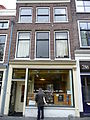
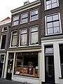
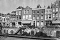
Category:Oudegracht 284, Utrecht
Jump to navigation
Jump to search
| Object location | | View all coordinates using: OpenStreetMap |
|---|
 | |||||
| Upload media | |||||
| Instance of |
| ||||
|---|---|---|---|---|---|
| Location | Utrecht, Netherlands | ||||
| Street address |
| ||||
| Located on street | |||||
| Heritage designation |
| ||||
 | |||||
|
This is a category about rijksmonument number 31091
|
| Address |
|
Media in category "Oudegracht 284, Utrecht"
The following 4 files are in this category, out of 4 total.
-
 Oudegracht 284.JPG 2,592 × 3,456; 4.35 MB
-
 Oudegracht.284.Utrecht.jpg 3,000 × 4,000; 5.52 MB
-
 Voorgevels - Utrecht - 20236784 - RCE.jpg 1,200 × 802; 208 KB
-
 Voorgevels - Utrecht - 20236787 - RCE.jpg 1,200 × 805; 191 KB


