Category:Oude pomp (Hillegom)
Jump to navigation
Jump to search
| Object location | | View all coordinates using: OpenStreetMap |
|---|
 | |||||
| Upload media | |||||
| Instance of | |||||
|---|---|---|---|---|---|
| Location | Hillegom, South Holland, Netherlands | ||||
| Street address |
| ||||
| Heritage designation |
| ||||
 | |||||
|
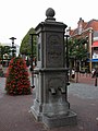
This is a category about rijksmonument number 22134
|
| Address |
|
Media in category "Oude pomp (Hillegom)"
The following 17 files are in this category, out of 17 total.
-
 HILLEGOM pompe.jpg 480 × 640; 242 KB
-
 Houttuin Hillegom 1.jpg 720 × 466; 87 KB
-
 Klokgeveltje en Oude Pomp - Hillegom - 20112926 - RCE.jpg 1,200 × 888; 228 KB
-
 Oude Pomp en Wapen van Friesland - Hillegom - 20112917 - RCE.jpg 1,190 × 1,200; 294 KB
-
 Pomp, detail - Hillegom - 20112841 - RCE.jpg 1,200 × 1,190; 249 KB
-
 Pomp, detail - Hillegom - 20112842 - RCE.jpg 1,200 × 1,192; 312 KB
-
 Pomp, detail - Hillegom - 20112843 - RCE.jpg 1,197 × 1,200; 275 KB
-
 Pomp, detail - Hillegom - 20112844 - RCE.jpg 1,200 × 1,192; 369 KB
-
 Pomp, detail - Hillegom - 20112845 - RCE.jpg 1,192 × 1,200; 370 KB
-
 Pomp, detail - Hillegom - 20112846 - RCE.jpg 1,190 × 1,200; 391 KB
-
 Pomp, detail - Hillegom - 20112847 - RCE.jpg 1,200 × 1,200; 559 KB
-
 Pomp, detail - Hillegom - 20112848 - RCE.jpg 1,200 × 1,192; 355 KB
-
 Pomp, detail - Hillegom - 20112849 - RCE.jpg 1,200 × 1,197; 454 KB
-
 Pomp, detail - Hillegom - 20112850 - RCE.jpg 1,190 × 1,200; 422 KB
-
 Pomp, overzicht - Hillegom - 20112840 - RCE.jpg 1,197 × 1,200; 279 KB
-
 Wapen van Friesland - Hillegom - 20112911 - RCE.jpg 1,188 × 1,200; 227 KB
-
 Wapen van Friesland - Hillegom - 20112932 - RCE.jpg 1,200 × 1,200; 316 KB


