Category:Oude Salviuskerk (Limbricht)
Jump to navigation
Jump to search
| Object location | | View all coordinates using: OpenStreetMap |
|---|
church in Limbricht, Netherlands  | |||||
| Upload media | |||||
| Instance of | |||||
|---|---|---|---|---|---|
| Dedicated to | |||||
| Location | Limbricht, Limburg, Netherlands | ||||
| Street address |
| ||||
| Located on street |
| ||||
| Architectural style | |||||
| Diocese | |||||
| Architect | |||||
| Heritage designation |
| ||||
| Religion or worldview | |||||
 | |||||
|
This is a category about rijksmonument number 33753
|
| Address |
|
Subcategories
This category has only the following subcategory.
I
Media in category "Oude Salviuskerk (Limbricht)"
The following 53 files are in this category, out of 53 total.
-
 Allee, overzichten - Limbricht - 20140242 - RCE.jpg 1,200 × 781; 219 KB
-
 Beekstraat Limbricht richting noordoost.jpg 2,592 × 1,456; 1.13 MB
-
 Detail noordgevel noord-oost hoek - Limbricht - 20140159 - RCE.jpg 788 × 1,200; 325 KB
-
 Exterieur - Limbricht - 20140147 - RCE.jpg 1,200 × 1,196; 241 KB
-
 Exterieur - Limbricht - 20140148 - RCE.jpg 1,200 × 1,197; 266 KB
-
 Exterieur - Limbricht - 20140149 - RCE.jpg 1,200 × 958; 112 KB
-
 Exterieur INGANG WESTGEVEL - Limbricht - 20303908 - RCE.jpg 1,200 × 800; 247 KB
-
 Exterieur OOSTGEVEL (KOOR) - Limbricht - 20278480 - RCE.jpg 788 × 1,200; 154 KB
-
 Exterieur OVERZICHT - Limbricht - 20263675 - RCE.jpg 1,200 × 775; 184 KB
-
 Exterieur OVERZICHT NOORDWEST ZIJDE - Limbricht - 20278478 - RCE.jpg 788 × 1,200; 163 KB
-
 Exterieur OVERZICHT OOSTGEVEL - Limbricht - 20278479 - RCE.jpg 1,200 × 788; 236 KB
-
 Exterieur OVERZICHT WESTZIJDE - Limbricht - 20303907 - RCE.jpg 799 × 1,200; 167 KB
-
 Exterieur TOEGANGSHEK - Limbricht - 20278476 - RCE.jpg 788 × 1,200; 198 KB
-
 Exterieur TOEGANGSHEK - Limbricht - 20278477 - RCE.jpg 788 × 1,200; 249 KB
-
 Gedeelte oostgevel - Limbricht - 20140156 - RCE.jpg 788 × 1,200; 225 KB
-
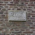 Gedeelte van bakstenen trapgevel met gevelsteen - Limbricht - 20337843 - RCE.jpg 1,195 × 1,200; 362 KB
-
 Gedeelte van bakstenen trapgevel met gevelsteen - Limbricht - 20337845 - RCE.jpg 1,199 × 1,200; 421 KB
-
 Gedeelte van bakstenen trapgevel met wapensteen - Limbricht - 20337839 - RCE.jpg 1,198 × 1,200; 311 KB
-
 Gedeelte van bakstenen trapgevel, detail gevelsteen - Limbricht - 20337842 - RCE.jpg 1,200 × 1,200; 424 KB
-
 Gedeelte zuidgevel koor tegen oostwand zuidbeuk - Limbricht - 20140158 - RCE.jpg 1,200 × 788; 312 KB
-
 Gevelsteen - Limbricht - 20337858 - RCE.jpg 1,198 × 1,200; 367 KB
-
 Het oude Salviuskerkje te Limbricht.jpg 6,340 × 5,485; 25.9 MB
-
 Ingang westgevel - Limbricht - 20140157 - RCE.jpg 1,200 × 788; 318 KB
-
 KAPEL - Limbricht - 20263658 - RCE.jpg 775 × 1,200; 237 KB
-

-

-

-
 Kerk vanuit het noord-oosten - Limbricht - 20140138 - RCE.jpg 842 × 1,200; 198 KB
-
 Kerk vanuit het zuiden - Limbricht - 20140139 - RCE.jpg 892 × 1,200; 184 KB
-
 Limbrichkerk1.jpg 2,304 × 1,728; 1.09 MB
-
 Limbrichkerk2.jpg 2,304 × 1,728; 1.4 MB
-
 LImbricht IV.jpg 2,953 × 1,964; 5.77 MB
-
 Limbricht IX.jpg 2,825 × 1,844; 4.23 MB
-
 Limbricht OudeKerk.jpg 766 × 1,024; 164 KB
-
 Limbricht V.jpg 2,946 × 1,959; 4.96 MB
-
 Limbricht VI.jpg 3,008 × 2,000; 3.78 MB
-
 Noord-west gevel - Limbricht - 20140155 - RCE.jpg 1,200 × 788; 224 KB
-

-
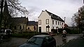 Platz Limbricht richting noorden.jpg 2,592 × 1,456; 1.24 MB
-
 Salvius Limbricht.JPG 1,968 × 2,986; 1.55 MB
-
 Salviuskerk 1.jpg 3,544 × 2,442; 5.16 MB
-
 Salviuskerk 2.jpg 3,673 × 2,517; 5.78 MB
-
 Salviuskerk 3.jpg 2,321 × 3,310; 4.06 MB
-
 Salviuskerkje limbricht.jpg 1,719 × 1,703; 552 KB
-
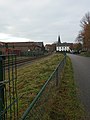
 Spoorwegovergang Platz Limbricht.jpg 3,120 × 4,160; 4 MB
-
 Voormalige tramhalte Limbricht.jpg 3,120 × 4,160; 4 MB
-
 West-zijde exterieur - Limbricht - 20140153 - RCE.jpg 951 × 1,200; 258 KB
-
 Westgevel en toren - Limbricht - 20140154 - RCE.jpg 788 × 1,200; 169 KB
-
 Zuid-oost zijde - Limbricht - 20140151 - RCE.jpg 1,200 × 961; 270 KB
-
 Zuid-oost zijde - Limbricht - 20140152 - RCE.jpg 947 × 1,200; 225 KB
-
 Zuid-zijde exterieur - Limbricht - 20140150 - RCE.jpg 1,200 × 946; 188 KB
-
 Zuidgevel - Limbricht - 20140226 - RCE.jpg 1,200 × 792; 168 KB
-
 Zuidgevel - Limbricht - 20140227 - RCE.jpg 1,200 × 788; 147 KB


_-_Limbricht_-_20278480_-_RCE.jpg)


