Category:Oude Rijksweg 108, Staphorst
Jump to navigation
Jump to search
| Object location | | View all coordinates using: OpenStreetMap |
|---|
 | |||||
| Upload media | |||||
| Instance of | |||||
|---|---|---|---|---|---|
| Location | Staphorst, Overijssel, Netherlands | ||||
| Street address |
| ||||
| Located on street |
| ||||
| Heritage designation |
| ||||
 | |||||
|
This is a category about rijksmonument number 34351
|
| Address |
|
Media in category "Oude Rijksweg 108, Staphorst"
The following 5 files are in this category, out of 5 total.
-
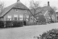 Aanzicht met 104 - Staphorst - 20204593 - RCE.jpg 1,200 × 805; 275 KB
-
 Linker zij- en achtergevel - Staphorst - 20204595 - RCE.jpg 1,197 × 1,200; 314 KB
-
 RM 34351-WLM(2).jpg 3,648 × 2,736; 2.97 MB
-
 RM 34351-WLM.jpg 3,515 × 2,591; 2.93 MB
-
 Voor- en linker zijgevel - Staphorst - 20204594 - RCE.jpg 1,195 × 1,200; 295 KB


.jpg)
