Category:Oude Kerkstraat 8, Delft
Jump to navigation
Jump to search
| Object location | | View all coordinates using: OpenStreetMap |
|---|
building in Delft, Netherlands  | |||||
| Upload media | |||||
| Instance of | |||||
|---|---|---|---|---|---|
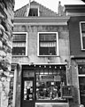
| Location | Delft, South Holland, Netherlands | ||||
| Street address |
| ||||
| Located on street | |||||
| Heritage designation |
| ||||
 | |||||
|
This is a category about rijksmonument number 12137
|
| Address |
|
Media in category "Oude Kerkstraat 8, Delft"
The following 3 files are in this category, out of 3 total.
-
 Delft - Oude Kerkstraat 8.jpg 1,644 × 2,388; 791 KB
-
 Gevels - Delft - 20052879 - RCE.jpg 803 × 1,200; 199 KB
-
 Voorgevel - Delft - 20052880 - RCE.jpg 961 × 1,200; 257 KB

