Category:Oude Kerk (Lunteren)
Jump to navigation
Jump to search
| Object location | | View all coordinates using: OpenStreetMap |
|---|
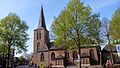
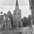
church building in Ede, Netherlands  | |||||
| Upload media | |||||
| Instance of | |||||
|---|---|---|---|---|---|
| Location | Lunteren, Gelderland, Netherlands | ||||
| Street address |
| ||||
| Located on street |
| ||||
| Heritage designation |
| ||||
| Significant event |
| ||||
 | |||||
Nederlands: Oude Kerk, Lunteren - anno 15e eeuw
|
This is a category about rijksmonument number 14480
|
| Address |
|
Subcategories
This category has only the following subcategory.
Media in category "Oude Kerk (Lunteren)"
The following 11 files are in this category, out of 11 total.
-
 6741 Lunteren, Netherlands - panoramio (22).jpg 2,048 × 1,155; 889 KB
-
 Interieur, aanzicht orgel - Lunteren - 20417562 - RCE.jpg 792 × 1,200; 151 KB
-

-
 Lunteren Dorpsstraat Gemeentearchief Ede GA06487.jpg 1,101 × 696; 503 KB
-
 Lunteren, de Oude Kerk positie2 foto5 RM14480 2012-03-11 15.02.JPG 4,416 × 3,312; 12.47 MB
-
 Lunteren-kerk-e.o..jpg 1,191 × 1,024; 273 KB
-
 Protestant church of Lunteren with Restaurant - panoramio.jpg 4,458 × 3,107; 2.58 MB
-
 RM14480 NH Kerk.JPG 3,960 × 3,147; 2.84 MB
-
 Toren - Lunteren - 20143075 - RCE.jpg 1,200 × 1,182; 290 KB
-
 Zicht op toren, die in de steigers staat - Lunteren - 20143074 - RCE.jpg 2,307 × 3,150; 1.59 MB
-
 Zicht op toren, die in de steigers staat - Lunteren - 20408778 - RCE.jpg 2,325 × 3,144; 1.54 MB
.jpg)


