Category:Oude Boteringestraat 17 (Groningen)
Jump to navigation
Jump to search
| Object location | | View all coordinates using: OpenStreetMap |
|---|
 | |||||
| Upload media | |||||
| Instance of | |||||
|---|---|---|---|---|---|
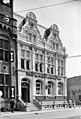
| Location | Groningen, Netherlands | ||||
| Street address |
| ||||
| Architectural style | |||||
| Heritage designation |
| ||||
 | |||||
Nederlands: In 1892 gebouwd als agentschap van de Nederlandsche Bank. Ontworpen door A. Salm.
|
This is a category about rijksmonument number 486040
|
| Address |
|
Media in category "Oude Boteringestraat 17 (Groningen)"
The following 6 files are in this category, out of 6 total.
-
 Groningen - Oude Boteringestraat 17.jpg 3,187 × 4,780; 7.11 MB
-
 Groningen Oude Boteringestraat 17 Rode Weeshuisstraat 121 tm 125.JPG 2,448 × 3,264; 4.4 MB
-
 Groningen Oude Boteringstraat.jpg 2,169 × 3,000; 5.45 MB
-
 LG-Groningen- Oude Boteringestraat 17.JPG 2,112 × 2,816; 1.67 MB
-
 Voor- en zijgevel - Groningen - 20093574 - RCE.jpg 805 × 1,200; 256 KB
-
 Voorgevel - Groningen - 20093575 - RCE.jpg 814 × 1,200; 216 KB


