Category:Oud Aalden 5, Aalden
Jump to navigation
Jump to search
| Object location | | View all coordinates using: OpenStreetMap |
|---|
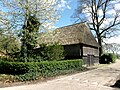
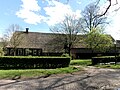
farmhouse in Coevorden, Netherlands  | |||||
| Upload media | |||||
| Instance of | |||||
|---|---|---|---|---|---|
| Location | Aalden, Coevorden, Drenthe, Netherlands | ||||
| Located on street |
| ||||
| Heritage designation |
| ||||
 | |||||
|
This is a category about rijksmonument number 41519
|
| Address |
|
Media in category "Oud Aalden 5, Aalden"
The following 11 files are in this category, out of 11 total.
-
 Achtergevel - Aalden - 20459408 - RCE.jpg 1,200 × 900; 142 KB
-
 Bijschuur Oud Aalden 5.jpg 4,608 × 3,456; 4.45 MB
-
 Boerderij met bijschuur vanaf de weg gezien - Aalden - 20003240 - RCE.jpg 1,200 × 812; 284 KB
-
 Boerderijen in landschap - Aalden - 20003243 - RCE.jpg 1,200 × 809; 298 KB
-
 Boerderijen met geboomte op de voorgrond - Aalden - 20003241 - RCE.jpg 1,200 × 810; 389 KB
-
 Oud Aalden 5 v1.jpg 4,608 × 3,456; 3.63 MB
-
 Oud Aalden 5 v2.jpg 4,608 × 3,456; 3.39 MB
-
 Overzicht boerderijen met schuur - Aalden - 20003242 - RCE.jpg 1,200 × 807; 249 KB
-

-

-
 Zijgevel woonged. - Aalden - 20459409 - RCE.jpg 1,200 × 900; 127 KB


