Category:Oud-Turnhout
Jump to navigation
Jump to search
Nederlands: Afbeeldingen van de gemeente Oud-Turnhout in de provincie Antwerpen in het noorden van België. Oud-Turnhout in nabij de gemeenten Ravels, Arendonk, Retie, Kasterlee en Turnhout (bron [1];[2])
municipality in Antwerp, Belgium  Sint-Antonius Abtkerk i Oud-Turnhout    Kommunens läge i provinsen Antwerpen. | |||||
| Upload media | |||||
| Instance of | |||||
|---|---|---|---|---|---|
| Part of |
| ||||
| Location | Arrondissement of Turnhout, Province of Antwerp, Flemish Region, Belgium | ||||
| Capital |
| ||||
| Official language |
| ||||
| Head of government |
| ||||
| Legal form |
| ||||
| Population |
| ||||
| Area |
| ||||
| Different from | |||||
| official website | |||||
 | |||||
Subcategories
This category has the following 7 subcategories, out of 7 total.
Media in category "Oud-Turnhout"
The following 10 files are in this category, out of 10 total.
-
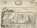 Lucas Vorsterman (II), Jacob van Werden - Priory Corsendonk in Turnhout.jpg 6,360 × 4,736; 4.8 MB
-
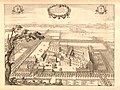 Lucas Vorsterman (II), Jacob van Werden (after) - Priory Corsendonk in Turnhout.jpg 2,500 × 1,879; 1.02 MB
-
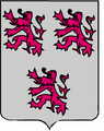
 Blason ville be Oud-Turnhout.svg 600 × 660; 76 KB
-
 Coat of arms of Oud-Turnhout.png 351 × 443; 27 KB
-
 Kapel van Rhoode.jpg 2,048 × 1,536; 875 KB
-

-
 Oud-Turnhout Vlag - 25502 - onroerenderfgoed.jpg 1,500 × 1,000; 100 KB
-
 Oud-Turnhout vlag.svg 843 × 563; 127 KB
-
 Oud-Turnhout Wapen - 25503 - onroerenderfgoed.jpg 1,000 × 1,500; 197 KB
-
 Oud-Turnhout wapen.svg 479 × 571; 175 KB
,_Jacob_van_Werden_-_Priory_Corsendonk_in_Turnhout.jpg)
,_Jacob_van_Werden_(after)_-_Priory_Corsendonk_in_Turnhout.jpg)


_-_154473_-_onroerenderfgoed.jpg)