Category:Otto-Maigler-See
Jump to navigation
Jump to search
lake in Germany  | |||||
| Upload media | |||||
| Instance of | |||||
|---|---|---|---|---|---|
| Part of | |||||
| Location | Hürth, Rhein-Erft District, Cologne Government Region, North Rhine-Westphalia, Germany | ||||
| Area |
| ||||
| Elevation above sea level |
| ||||
 | |||||
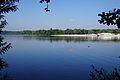
Deutsch: Der Otto-Maigler-See ist ein nach dem Braunkohleabbau entstandener See der Stadt Hürth im Rhein-Erft-Kreis
English: The Otto-Maigler-See is a lake by exhausted opencast working in the area of Hürth, North Rhine-Westphalia
Pages in category "Otto-Maigler-See"
This category contains only the following page.
Media in category "Otto-Maigler-See"
The following 30 files are in this category, out of 30 total.
-
 Aerial view of the lake and sand beach at Otto-Maigler-See in Hürth, Germany (48331367942).jpg 5,464 × 3,640; 12.75 MB
-

-
 Aerial view of the southern end of Otto-Maigler-See in Hürth, Germany (48331216461).jpg 5,464 × 3,070; 11.09 MB
-
 Blick auf den nördlichen Bereich vom Otto-Maigler-See in Hürth, Deutschland (48331223481).jpg 5,464 × 3,640; 13.38 MB
-

-
 Huerth 10-2017 img02 OttoMaiglerSee.jpg 5,142 × 3,428; 7.53 MB
-
 Huerth 10-2017 img03 OttoMaiglerSee.jpg 5,012 × 3,341; 7.04 MB
-
 Höckerschwan, Otto-Maigler-See.jpg 960 × 720; 71 KB
-
 Hürth-Burbacher-Otto-Maigler-See.JPG 4,225 × 2,806; 5.96 MB
-

-
 Luftbild vom Sandstrand Otto-Maigler-See in Hürth, Deutschland (48331234901).jpg 5,464 × 3,070; 13.66 MB
-
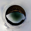 Otto Maigler See – Little Planet 180° Panorama.jpg 3,685 × 3,666; 998 KB
-
 Otto-Maigler-See - Kugelprojektion (Panorama).jpg 5,000 × 1,308; 756 KB
-
Otto-Maigler-See Huerth asv10-2017 video.webm 3 min 24 s, 1,920 × 1,080; 154.4 MB
-
 Otto-Maigler-See Strandbad.jpg 6,000 × 4,000; 6.41 MB
-
 Otto-Maigler-See-0ffizieller-Badestrand.JPG 4,272 × 2,848; 2.6 MB
-
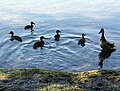 Otto-Maigler-See-Fauna.JPG 3,376 × 2,560; 1.96 MB
-
 Otto-Maigler-See-Flora.JPG 4,272 × 2,848; 2.16 MB
-
 Otto-Maigler-See-Hürth-Detail.JPG 2,536 × 4,096; 4.43 MB
-
 Otto-Maigler-See-Hürth-Fauna-Januar-2009.JPG 4,272 × 2,848; 2.58 MB
-
 Otto-Maigler-See-Hürth-Info.JPG 2,848 × 4,272; 3.03 MB
-
 Otto-Maigler-See-Hürth-Januar-2009.JPG 4,272 × 2,848; 3.02 MB
-
 Otto-Maigler-See-Hürth-Rudersport.JPG 4,272 × 2,848; 4.21 MB
-
 Otto-Maigler-See-Hürth-Rundweg.JPG 4,272 × 2,848; 3.77 MB
-
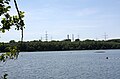 Otto-Maigler-See-Industriestseite.JPG 4,208 × 2,776; 2.32 MB
-
 Otto-Maigler-See-Uferbereich-Süd-Ost.JPG 4,072 × 2,848; 3.42 MB
-
 Otto-Maigler-See-Uferzone.JPG 4,144 × 2,848; 2.78 MB
-
 Otto-Maigler-Süd-Westseite.JPG 4,272 × 2,848; 1.76 MB
-
 Sandstrand am Otto-Maigler-See in Hürth, Deutschland (48331214526).jpg 5,464 × 3,070; 12.28 MB
-
 Sandy beach at the Otto-Maigler-See in Hürth, Germany (48331338677).jpg 5,464 × 3,640; 14.66 MB
.jpg)
.jpg)
.jpg)
.jpg)
.jpg)


.jpg)
.jpg)


.jpg)
.jpg)
.jpg)