Category:Ossory Lodge Mass Path
former mass path leading from Ballyfoyle Road to Dunmore Church and National School, Co. Kilkenny | |||||
| Upload media | |||||
| Instance of | |||||
|---|---|---|---|---|---|
| Location | County Kilkenny, Leinster, Ireland | ||||
| Terminus |
| ||||
 | |||||
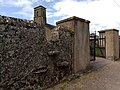
"Ossory Lodge Mass Path" is not an official name, but is used here to differentiate it from the other two mass paths leading to Dunmore Church and National School, Nelly Meany's Gate Mass Path and Charlie's Walk Mass Path. This mass path started on the Ballyfoyle Road (serving people living along there and on Radestown Lane), entered possibly at the townland boundary between Dunmore Park and Baun, because Dunmore Park was owned by the Ormondes of Kilkenny Castle who would not allow trespassing, went along a wall and came out at Ossory Lodge[1]. Neither the entry nor the exit point are discernible as such now, but a foot path ("F.P.") is marked on old Ordnance Survey maps. The exit point onto the Castlecomer Road is walled up, see photograph. There is however still a stepover stile in the wall of Dunmore Churchyard.
References
[edit]- ↑ Oral history of a resident on Radestown Lane who walked this way to Dunmore National School and Church, August 2023
Media in category "Ossory Lodge Mass Path"
The following 3 files are in this category, out of 3 total.
-
 2023-08-10 entrance to Ossory Lodge Mass path.jpg 4,032 × 2,016; 3.09 MB
-
 2023-08-10 Ossory Lodge mass path former access.jpg 4,032 × 2,016; 2.71 MB
-
 Stepover stile.jpg 4,160 × 3,120; 4.98 MB


