Category:Oso mudslide
Jump to navigation
Jump to search
2014 landslide east of Oso, Washington, United States  | |||||
| Upload media | |||||
| Instance of | |||||
|---|---|---|---|---|---|
| Location |
| ||||
| Point in time |
| ||||
| Number of casualties |
| ||||
| Number of deaths |
| ||||
| Number of injured |
| ||||
 | |||||
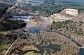
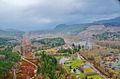
English: On Saturday, March 22, 2014, at 10:37 a.m. local time, a major mudslide occurred 4 miles (6.4 km) east of Oso, Washington, United States, when a portion of an unstable hillside known as the "Hazel Landslide" collapsed, sending mud and debris across the North Fork of the Stillaguamish River and onto the adjacent river valley, covering an area of approximately 1 square mile (2.6 km2).
Media in category "Oso mudslide"
The following 66 files are in this category, out of 66 total.
-
 2014 Washington Landslide.jpg 1,800 × 1,196; 2.03 MB
-

-
 Memorial site at Oso, seen from Washington State Route 530 - 01.jpg 6,000 × 4,000; 12.35 MB
-
 Mountainside after the slide at Oso, seen from Washington State Route 530 - 01.jpg 6,000 × 4,000; 11.33 MB
-
 Mountainside after the slide at Oso, seen from Washington State Route 530 - 02.jpg 6,000 × 4,000; 10.98 MB
-
 National Guard decontamination tents.jpg 2,694 × 1,754; 3.52 MB
-
 Oso Landslide (east of Oso, Washington State, USA) 2.jpg 1,800 × 1,125; 3.23 MB
-
 Oso Landslide aerial.jpg 2,907 × 1,893; 2.08 MB
-
 Oso landslide geomorphology map.png 1,139 × 750; 1.66 MB
-
 Oso Mudslide 22 March 2014 Aerial view 2.jpg 1,224 × 1,632; 819 KB
-
 Oso Mudslide 22 March 2014 Aerial view.jpg 1,632 × 1,224; 1.33 MB
-
 Oso Mudslide 22 March 2014 Mountain view.jpg 1,632 × 1,224; 1.35 MB
-
 Oso mudslide 22 March 2014.jpg 1,224 × 1,632; 905 KB
-
 Oso Mudslide 28 March 2014 search and rescue 2.jpg 4,928 × 3,264; 5.4 MB
-
 Oso Mudslide 28 March 2014 search and rescue.jpg 2,833 × 4,276; 2.5 MB
-
 Oso Mudslide 29 March 2014 aerial view 1.jpg 4,928 × 3,264; 7.1 MB
-
 Oso Mudslide 29 March 2014 aerial view 2.jpg 4,928 × 3,264; 7.16 MB
-
 Oso Mudslide 29 March 2014 aerial view 3.jpg 4,928 × 3,264; 13.42 MB
-
 Oso Mudslide 29 March 2014 search and recover.jpg 3,264 × 4,928; 9.06 MB
-
 Oso Mudslide 29 March 2014 search.jpg 3,264 × 4,928; 5.59 MB
-
 Oso Mudslide 29 March 2014.jpg 3,264 × 4,928; 8.55 MB
-
 Oso, WA Landslide - panoramio.jpg 2,048 × 1,536; 1.02 MB
-

-
 P042214PS-0143 (14328814491).jpg 1,500 × 1,000; 283 KB
-

-
 Stillaguamish River 1198.JPG 4,272 × 2,848; 7.29 MB
-

-
 Washington National Guard (13445940143).jpg 3,872 × 2,592; 4 MB
-
 Washington National Guard (13445941263).jpg 1,224 × 1,632; 502 KB
-
 Washington National Guard (13446018273).jpg 3,872 × 2,592; 4.8 MB
-
 Washington National Guard (13446164234).jpg 2,472 × 2,023; 2.42 MB
-
 Washington National Guard (13446166494).jpg 1,632 × 1,224; 491 KB
-
 Washington National Guard (13446232114).jpg 3,872 × 2,592; 4.1 MB
-
 Washington National Guard (13449007893).jpg 3,264 × 2,448; 584 KB
-
 Washington National Guard (13450529555).jpg 1,224 × 1,632; 311 KB
-
 Washington National Guard (13450530375).jpg 1,224 × 1,632; 379 KB
-
 Washington National Guard (13466674925).jpg 1,632 × 1,224; 352 KB
-
 Washington National Guard (13466676185).jpg 3,264 × 4,928; 8.53 MB
-
 Washington National Guard (13466677295).jpg 3,871 × 3,017; 7.77 MB
-
 Washington National Guard (13466679335).jpg 4,928 × 3,264; 3.49 MB
-
 Washington National Guard (13466780283).jpg 4,928 × 3,264; 2.75 MB
-
 Washington National Guard (13467026174).jpg 3,264 × 4,928; 2.04 MB
-
 Washington National Guard (13467026984).jpg 4,928 × 3,264; 3.34 MB
-
 Washington National Guard (13471821655).jpg 2,448 × 3,264; 3.09 MB
-
 Washington National Guard (13471822695).jpg 3,872 × 2,592; 4.55 MB
-
 Washington National Guard (13471925323).jpg 3,872 × 2,592; 4.83 MB
-
 Washington National Guard (13472170314).jpg 3,872 × 2,592; 3.75 MB
-
 Washington National Guard (13487803335).jpg 4,928 × 3,264; 3.08 MB
-
 Washington National Guard (13487803415).jpg 4,928 × 3,264; 2.55 MB
-
 Washington National Guard (13487803685).jpg 4,928 × 3,264; 2.51 MB
-
 Washington National Guard (13488167394).jpg 2,833 × 4,276; 2.44 MB
-
 Washington National Guard (13488167654).jpg 3,264 × 4,928; 4.85 MB
-
 Washington National Guard (13488167964).jpg 4,928 × 3,264; 4.74 MB
-
 Washington National Guard (13488168124).jpg 4,928 × 3,264; 2.75 MB
-
 Washington National Guard (13488168684).jpg 3,264 × 4,928; 2.46 MB
-
 Washington National GUard (13495053814).jpg 2,448 × 3,264; 596 KB
-
 Washington National Guard (13537998065).jpg 1,356 × 2,048; 518 KB
-
 Washington National Guard (13538144813).jpg 1,357 × 2,048; 528 KB
-
 Washington National Guard (13538145933).jpg 1,600 × 1,200; 331 KB
-
 Washington National Guard (13538317314).jpg 1,356 × 2,048; 640 KB
-
 Washington National Guard (13540603443).jpg 1,024 × 678; 512 KB
-
 Washington National Guard (13540825104).jpg 1,024 × 678; 571 KB
-
 Washington National Guard (13580930625).jpg 768 × 1,024; 355 KB
-
 Washington National Guard (13691321235).jpg 3,776 × 2,784; 5.48 MB
-
 Washington National Guard (13691629464).jpg 2,072 × 2,624; 2.9 MB
-
 Washington State Route 530 - headed east into the slide area at Oso 01.jpg 6,000 × 4,000; 13.98 MB


_2.jpg)


.jpg)


.jpg)
.jpg)
.jpg)
.jpg)
.jpg)
.jpg)
.jpg)
.jpg)
.jpg)
.jpg)
.jpg)
.jpg)
.jpg)
.jpg)
.jpg)
.jpg)
.jpg)
.jpg)
.jpg)
.jpg)
.jpg)
.jpg)
.jpg)
.jpg)
.jpg)
.jpg)
.jpg)
.jpg)
.jpg)
.jpg)
.jpg)
.jpg)
.jpg)
.jpg)
.jpg)
.jpg)
.jpg)
.jpg)
