Category:Ortspyramide Reichenhain
Jump to navigation
Jump to search
| Object location | | View all coordinates using: OpenStreetMap |
|---|
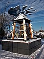
Deutsch: Die Ortspyramide Chemnitz-Reichenhain hat ihren Standort im Genossenschaftsweg nahe der Grundschule.
Media in category "Ortspyramide Reichenhain"
The following 9 files are in this category, out of 9 total.
-
 Ortspyramide Reichenhain (1).jpg 3,769 × 2,827; 2.72 MB
-
 Ortspyramide Reichenhain (2).jpg 3,000 × 4,000; 2.74 MB
-
 Ortspyramide Reichenhain (3).jpg 3,000 × 4,000; 3.13 MB
-
 Ortspyramide Reichenhain (4).jpg 3,530 × 2,647; 2.66 MB
-
 Ortspyramide Reichenhain, Figuren (1).jpg 3,000 × 4,000; 2.44 MB
-
 Ortspyramide Reichenhain, Figuren (2).jpg 2,578 × 3,438; 1.51 MB
-
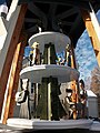 Ortspyramide Reichenhain, Figuren (3).jpg 3,000 × 4,000; 2.26 MB
-
 Ortspyramide Reichenhain, Figuren (4).jpg 3,000 × 4,000; 2.36 MB
-
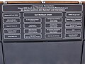 Ortspyramide Reichenhain, Infotafel.jpg 2,802 × 2,101; 1.22 MB
.jpg)
.jpg)
.jpg)
.jpg)
.jpg)
.jpg)
.jpg)
.jpg)
