Category:Ortsbildschutzzone Gais AR
Jump to navigation
Jump to search
| Object location | | View all coordinates using: OpenStreetMap |
|---|
| NO WIKIDATA ID FOUND! Search for Ortsbildschutzzone Gais AR on Wikidata | |
| Upload media |
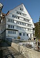
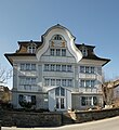
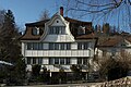
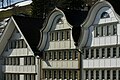
- Deutsch: Die Ortsbildschutzzone von nationaler Bedeutung bezeichnet den Dorfplatz von Gais, mit den umliegenden Häusern. Gais wurde 1977 für seinen Dorfplatz mit dem Wakkerpreis ausgezeichnet.
Subcategories
This category has the following 9 subcategories, out of 9 total.
E
H
- Haus (Dorfplatz 1, Gais AR) (1 F)
- Haus (Dorfplatz 4, Gais AR) (3 F)
- Haus (Dorfplatz 8, Gais AR) (1 F)
- Haus (Dorfplatz 9, Gais AR) (1 F)
M
Media in category "Ortsbildschutzzone Gais AR"
The following 12 files are in this category, out of 12 total.
-
 Dorfplatz 2 Gais AR 1.JPG 2,655 × 3,835; 2.02 MB
-
 Dorfplatz 5 Gais AR UBS.JPG 2,591 × 3,742; 2.45 MB
-
 Dorfplatz Gais AR 1.JPG 3,764 × 2,759; 2.33 MB
-
 Dorfplatz Gais AR 2.JPG 4,149 × 2,638; 2.39 MB
-
 Gais AR Dorfplatz Panorama 1.jpg 6,351 × 1,435; 6.67 MB
-
 Gais AR Dorfplatz Panorama.jpg 6,480 × 1,748; 2.81 MB
-
 Hinterdorf 1 Gais AR.JPG 2,848 × 4,272; 3.24 MB
-
 Hinterdorf 5 Gais AR.jpg 3,465 × 3,771; 2.18 MB
-
 Hinterdorf 7 Gais AR.JPG 2,475 × 3,368; 1.2 MB
-
 Langgasse 10 Gais AR.JPG 4,110 × 2,747; 2.58 MB
-
 Langgasse 2 4 6 Gais AR .JPG 4,178 × 2,770; 2.26 MB
-
 Langgasse 2 4 6 Gais AR.JPG 4,062 × 2,681; 2.28 MB


