Category:Original Norwich and Worcester Railroad right-of-way in Norwich
Jump to navigation
Jump to search
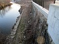
English: Shortly after its 1840 opening, the Norwich and Worcester Railroad was extended from its Norwich station to a steamboat wharf on the Thames River. Three years later, a bridge was built across the Shetucket River west of Thames Street as part of an extension south to Allyn's Point. In 1854, the Norwich Connection was built, extending west along the waterfront to the New London Northern. Around 1875, the opening of the Laurel Hill Tunnel and Shetucket River Bridge replaced the 1843-built bridge. The original route to the wharf and the Norwich Connection remained in use. The 1899 extension from Allyn's Point to Groton largely obviated the use of both older routes, though they remained intact for some time afterwards. Portions of the 1840- and 1843-built rights of way are still visible.
Subcategories
This category has the following 2 subcategories, out of 2 total.
N
- Norwich wharf station (18 F)
S
Media in category "Original Norwich and Worcester Railroad right-of-way in Norwich"
The following 10 files are in this category, out of 10 total.
-
 Abandoned Norwich and Worcester ROW in Norwich (1), December 2018.jpg 5,184 × 3,888; 4.86 MB
-
 Abandoned Norwich and Worcester ROW in Norwich (2), December 2018.jpg 5,184 × 3,888; 5.78 MB
-
 Abandoned ROW in Norwich (1), March 2012.JPG 4,320 × 3,240; 3.71 MB
-
 Abandoned ROW in Norwich (2), March 2012.jpg 4,878 × 2,258; 2.99 MB
-
 Aerial view, Norwich, Conn (88825).jpg 3,279 × 2,067; 3.11 MB
-
 Laurel Hill and bridge postcard.jpg 833 × 528; 71 KB
-

-
 Panorama along the Shetucket River, March 2012.jpg 4,910 × 2,250; 2.37 MB
-

-

,_December_2018.jpg)
,_December_2018.jpg)
,_March_2012.JPG)
,_March_2012.jpg)
.jpg)


,_Feb._15,_1886,_from_Robert_N._Dennis_collection_of_stereoscopic_views.jpg)
,_Feb._15,_1886,_from_Robert_N._Dennis_collection_of_stereoscopic_views.png)