Category:OpenStreetMap review needed of communes of Eure-et-Loir
Jump to navigation
Jump to search
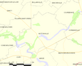
Français : Péronville est une commune du département d'Eure-et-Loir. La limite départementale (ligne pointillée rouge) entre cette commune et les communes de Varize, Bazoches-en-Dunois et Guillonville est une anomalie et doit être supprimée dans les cartes concernées de l'Eure-et-Loir et du Loiret.
English: Péronville is à municipality of Eure-et-Loir department. The department boundary (red line) between this municipality and the Varize, Bazoches-en-Dunois and Guillonville municipalities is not right and must be suppressed within all the Eure-et-Loir and Loiret departments maps.
Media in category "OpenStreetMap review needed of communes of Eure-et-Loir"
The following 9 files are in this category, out of 9 total.
-
 Map commune FR insee code 28028.png 756 × 605; 29 KB
-
 Map commune FR insee code 28101.png 756 × 605; 24 KB
-
 Map commune FR insee code 28190.png 756 × 605; 28 KB
-
 Map commune FR insee code 28283.png 756 × 605; 24 KB
-
 Map commune FR insee code 28295.png 756 × 605; 35 KB
-
 Map commune FR insee code 28296.png 756 × 605; 30 KB
-
 Map commune FR insee code 28330.png 756 × 605; 19 KB
-
 Map commune FR insee code 28400.png 756 × 605; 26 KB
-
 Map commune FR insee code 28410.png 756 × 605; 27 KB


