Category:OpenStreetMap maps of Staffordshire
Jump to navigation
Jump to search
Media in category "OpenStreetMap maps of Staffordshire"
The following 19 files are in this category, out of 19 total.
-
 Burton & Swadlincote Green Belt map.svg 1,042 × 1,042; 2.31 MB
-
 CannockGreatWyrley.png 664 × 850; 715 KB
-
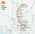 Chase line.png 1,277 × 1,208; 1.4 MB
-
 Coventry Canal Map.png 1,203 × 1,567; 2.04 MB
-
 Crewe–Derby line.png 2,025 × 1,481; 2.22 MB
-
 Cross-City Line Map (alt version).png 1,240 × 1,244; 1.5 MB
-
 Cross-City Line.png 1,391 × 1,347; 1.87 MB
-
 Erikssonmap.JPG 495 × 358; 38 KB
-
 Leicester–Burton upon Trent line.png 1,535 × 1,225; 1.47 MB
-
 PotteriesBUA.png 745 × 850; 867 KB
-
 Rugby–Birmingham–Stafford line.png 2,022 × 1,730; 3.15 MB
-
 Stafford Map.png 1,165 × 1,316; 1.58 MB
-
 Stafford–Manchester line.png 1,546 × 1,868; 2.31 MB
-
 Staffs & Worcs Canal Map.png 918 × 2,474; 2.59 MB
-
 Stoke-on-Trent green belt.svg 1,644 × 1,046; 1.92 MB
-
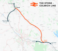 Stone-Colwich Line.png 1,819 × 1,598; 1.29 MB
-
 Tamworth map.png 750 × 715; 724 KB
-
 Trent & Mersey Canal map.png 1,152 × 855; 1.45 MB
-
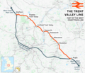 Trent Valley line.png 2,022 × 1,730; 3.15 MB


.png)


