Category:OpenStreetMap maps of São Tomé and Príncipe
Jump to navigation
Jump to search
Media in category "OpenStreetMap maps of São Tomé and Príncipe"
The following 8 files are in this category, out of 8 total.
-
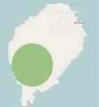 Distribution range of the Sao Tome Ibis.png 938 × 1,006; 302 KB
-

-
-

-
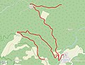
 Principe map.png 629 × 724; 27 KB
-
 Príncipe2021OSM.png 1,901 × 2,866; 633 KB
-
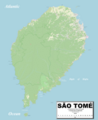
 Sao Tome map.png 907 × 1,157; 426 KB
-
 SãoTomé2021OSM.png 4,372 × 5,372; 4.09 MB


