Category:Oosteinde 46, Blijham
Jump to navigation
Jump to search
| Object location | | View all coordinates using: OpenStreetMap |
|---|
garden in Bellingwedde, Netherlands  | |||||
| Upload media | |||||
| Instance of | |||||
|---|---|---|---|---|---|
| Part of | |||||
| Location | Blijham, Westerwolde, Groningen, Netherlands | ||||
| Heritage designation |
| ||||
 | |||||
|
This is a category about rijksmonumentcomplex number 520897
|
Boerderij:
|
This is a category about rijksmonument number 520898
|
Tuinhuis:
|
This is a category about rijksmonument number 520899
|
Landarbeiderswoning:
|
This is a category about rijksmonument number 520900
|
Tuin:
|
This is a category about rijksmonument number 520901
|
| Address |
|
Media in category "Oosteinde 46, Blijham"
The following 17 files are in this category, out of 17 total.
-
 De Boschplaatse Blijham 1.jpg 3,648 × 2,736; 2.2 MB
-
 De Boschplaatse Blijham 2.jpg 2,736 × 3,648; 2.32 MB
-
 De Boschplaatse Blijham 3.jpg 3,648 × 2,736; 2.43 MB
-
 De Boschplaatse Blijham 4.jpg 2,736 × 3,648; 2.26 MB
-
 Deur naar woonkamer - Blijham - 20035772 - RCE.jpg 1,200 × 1,192; 239 KB
-
 Gang - Blijham - 20035770 - RCE.jpg 1,193 × 1,200; 245 KB
-
 Gang - Blijham - 20035771 - RCE.jpg 1,195 × 1,200; 195 KB
-
 Linker zijgevel - Blijham - 20035766 - RCE.jpg 1,200 × 1,199; 442 KB
-
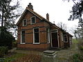
 Oosteinde46 tuinhuis.JPG 4,000 × 3,000; 2.62 MB
-
 Oosteinde48 Arbeiderswoning.JPG 4,000 × 3,000; 2.57 MB
-
 Overzicht - Blijham - 20035764 - RCE.jpg 1,198 × 1,200; 415 KB
-
 Overzicht achtergevel - Blijham - 20035769 - RCE.jpg 1,200 × 1,199; 359 KB
-
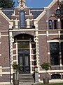
 Overzicht voorgevel - Blijham - 20365070 - RCE.jpg 1,200 × 1,197; 475 KB
-
 Plafond - Blijham - 20035773 - RCE.jpg 1,186 × 1,200; 303 KB
-
 Rechter zijgevel - Blijham - 20035767 - RCE.jpg 1,193 × 1,200; 366 KB
-
 Rechter zijgevel - Blijham - 20035768 - RCE.jpg 1,200 × 1,197; 464 KB
-
 Voorgevel - Blijham - 20035765 - RCE.jpg 1,188 × 1,200; 427 KB


