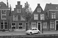
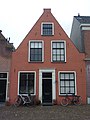
Category:Oostdwarsgracht 18, Leiden
Jump to navigation
Jump to search
| Object location | | View all coordinates using: OpenStreetMap |
|---|
building in Leiden, Netherlands  | |||||
| Upload media | |||||
| Instance of | |||||
|---|---|---|---|---|---|
| Location | Leiden, South Holland, Netherlands | ||||
| Street address |
| ||||
| Located on street | |||||
| Heritage designation |
| ||||
 | |||||
|
This is a category about rijksmonument number 25258
|
| Address |
|
Media in category "Oostdwarsgracht 18, Leiden"
The following 6 files are in this category, out of 6 total.
-
 Gevels - Leiden - 20136709 - RCE.jpg 1,200 × 787; 176 KB
-
 Leiden - Oost Dwarsgracht 18.JPG 2,736 × 3,648; 3.9 MB
-
 Oostdwarsgracht 18, Leiden.JPG 2,848 × 4,272; 2.45 MB
-
 Overzicht - Leiden - 20136705 - RCE.jpg 1,200 × 961; 222 KB
-
 Overzicht - Leiden - 20136706 - RCE.jpg 1,200 × 963; 221 KB
-
 Voorgevel - Leiden - 20136707 - RCE.jpg 1,200 × 961; 277 KB


